Over the last year, hundreds of community members have given input to shape the Vision Plan. The ideas and updated maps were the focus on an open house in January. The plan has been updated based on comments received from the community and project committees. The Steering Committee will meet on April 2 to discuss making a recommendation to the Board of County Commissioners to accept the Sunrise Corridor Community Vision Plan.
Draft Sunrise Corridor Community Vision Plan - March 2025
Draft Sunrise Gateway Corridor Refinement Plan - Updated March 2025
Video of Draft Sunrise Gateway Corridor Plan – January 2025
Display boards from open house – January 2025
Community planning to identify ways to address the needs of people who live, work, learn, shop, and travel in the Sunrise area, today and in the future.
The Sunrise Corridor community is a busy place – with hundreds of homes, businesses and two major highways – and is expected to keep growing.
Clackamas County has been working with the Oregon Department of Transportation, Metro and Happy Valley to ask everyone who is part of the Sunrise Corridor community what is needed in the present and the future for residents, businesses, travelers, wildlife and the environment.
Through this project, hundreds of people have helped shape the vision, goals, and draft list of actions for land use, housing, community and environmental health, transportation and other infrastructure necessary to support a thriving future for all.
Show your support for Sunrise!
Metro is currently gathering public input to decide which projects to fund, and we need your voice. One way to share your thoughts is by submitting a short video, but you can also provide feedback directly in writing. Whether you submit a video or just share your feedback, your input will make a difference in shaping the future of this area. Please take a moment to share your thoughts, and feel free to spread the word to your neighbors. Together, we can bring much-needed investments to our community!
Here’s how you can help!
1. Submit input through the Metro form (two minutes)
Visit https://storymaps.arcgis.com/stories/610459d41a6f4a1b942a4372fed450b4
Read and learn more about the projects
Visit the “Share Your Feedback” Section and submit your input about the benefits of supporting the Sunrise Gateway Corridor/ Highway 212 project
2. Submit email or video testimony
Find testimony tips at https://www.clackamas.us/news/2025-04-04/your-voice-matters-help-shape-the-future-of-the-sunrise-gateway-corridor.
3. Share with your network
Share the opportunity with neighbors, friends, coworkers, and community groups to help spread the word. If you are on a social platform with hashtags, please use #SupportSunriseCorridor.
Help us build a community coalition!
Clackamas County, in partnership with the community, is building a coalition to support implementation of the Sunrise Corridor Community Vision Plan. The plan, developed with the community, is expected to be completed in spring 2025. Residents, workers, businesses, organizations, and public agencies will then work together to implement projects recommended in the plan that benefit the Sunrise Corridor Community by:
- Improving safety
- Increasing health and well-being
- Strengthening business opportunities and jobs
- Enhancing access to nature and recreation
- Preventing displacement of homes and businesses
- Creating new and lasting partnerships
To sign-up for the coalition or get more information, please contact Adam Torres, in the Clackamas County Department of Transportation & Development, at atorres@clackamas.us.
Quick Facts
WHERE
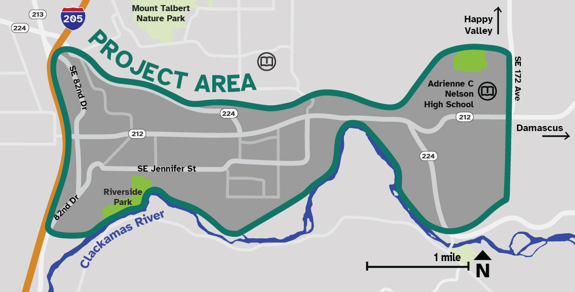
The Sunrise Corridor community is a five-square mile area in the valley bounded by the Clackamas River on the south, forested low hills to the north, I-205 to the west and 172nd Avenue to the east.
WHO
The project area is home to 7,600 residents and 700 businesses with more than 14,000 employees.
WHAT
It is one of the busiest freight distribution centers in the region and state, and is bisected by OR212/224.
Vision and Actions
The Sunrise Corridor Community Vision Plan – with vision, goals and actions – is almost ready. The actions in the plan will be shared for community review and input in early 2025. The Draft Sunrise Gateway Corridor Refinement Plan is also being included in this process and will include updated maps and next steps for regional transportation investments in the area, including extending OR 212/Sunrise and a multi-use path east to SE 172nd Avenue.
Goals
Create a safe and resilient transportation network for everyone that improves travel opportunities for pedestrians, bicyclists, transit riders, and drivers.

Enhance health, wellbeing, and sustainability.

Promote complete communities to meet the basic needs of all residents.

Support economic development.

Preserve and enhance local identity, including historical and cultural assets.

Create lasting improvements through agency coordination and partnerships.
The goals were shaped by community input in winter/spring 2024 and adopted by the project’s Steering Committee in June 2024.
Proposed Actions
Community Engagement
Public engagement is a key component of the Sunrise Corridor Community Visioning project. Extensive public feedback means the final plan will better reflect the needs of people who live, work, visit, and play in the Sunrise Corridor community today and in the future.
The engagement process prioritizes populations and communities historically excluded and underserved by transportation and land use investments. Outreach activities include open houses, online surveys, focus groups, presentations, and information pop-ups in community gathering areas.
The project has also convened committees, noted below, to ensure community members, project partners and technical experts are involved in project development and decision-making.
Advisory Groups and Committees
Technical Advisory Committee
Composed of staff from agencies that provide expert support and technical review of the work. This ensures that actions listed in the plan are feasible.
Project Timeline
PHASE 1
(Completed June 2024)
Gathered community feedback to develop vision, goals and objectives, identify opportunities and challenges, and collect ideas for future improvements in the project area. The vision and goals were approved by the Steering Committee.
PHASE 2
(Completed October 2024)
Worked with the community to explore ideas for how to address economic development, land use, green space, public health, and transportation challenges.
PHASE 3
(November 2024 - Spring 2025)
Seek community feedback on actionable steps and projects that support the vision and goals of the Sunrise Corridor community.
Clackamas County and the consultant team are drafting the Sunrise Corridor Community Vision Plan (document) based on community feedback and committee review from 2024. The final plan will outline steps or actions needed to reach the goals stated above. For each action, the plan will identify partners, anticipated timeline, potential cost range and, for some, potential funding sources.
- A draft of the Sunrise Corridor Community Vision Action Plan will be ready for public review in January 2025.
- As part of the transportation section, the Vision Plan will reference the Sunrise Gateway Corridor Refinement Plan for the major highway corridor through the area. The transportation refinement plan is being drafted in cooperation with the Oregon Department of Transportation (ODOT) and the City of Happy Valley. It will include updated maps and next steps for recommended regional transportation investments in the area, including creating 15 miles of new walking and biking improvements.
The Board of County Commissioners will consider the Vision Plan in spring 2025. Partner agencies ODOT, Metro, and City of Happy Valley will also be involved in reviewing the final plan.
What happens after the Vision Plan is complete?
After the Sunrise Corridor Community Vision Plan is adopted by the Board of County Commissioners, community leaders and agency staff can organize and work together to seek funding for and implement specific projects.
Frequently Asked Questions
Stay Connected
Get project updates and news about opportunities to be part of the Sunrise Corridor Community Visioning Project.
Meetings and events
| April 2, 2025 | Steering Committee Meeting #6 |
| Jan. 23, 2025 | Open House #3 |
| Nov. 14, 2024 | Steering Committee Meeting #5 |
| Sept. 24, 2024 | Open House Open house flyer |
| Sept. 16-Oct. 6, 2024 | Online opportunity to share input |
| Sept. 4, 2024 | Steering Committee Meeting #4 |
| June 5, 2024 | Steering Committee Meeting #3 |
| April 10, 2024 | Open House Project display boards |
| March 20, 2024 | Steering Committee Meeting #2 |
| Jan. 31, 2024 | Steering Committee Meeting #1 |
| Oct. 5, 2023 | C4 meeting presentation |
| Sept. 14, 2021 | Board of County Commissioners Policy Session Performance Clackamas Update - Sunrise packet video |
Technical Information and Reports
| Existing conditions | |
|---|---|
| Background information and data about the project area is gathered and evaluated to provide information to the Project Team and Steering Committee. Much of that information is presented in technical memos on various "existing conditions" topics. These technical memos are posted below. | |
| Community and business | technical memo |
| Economic | technical memo |
| Historical context | technical memo presentation |
| Land use | technical memo |
| Plans review | technical memo |
| Public health | technical memo |
| Transportation | technical memo |
| Engagement reports | |
|---|---|
| The Sunrise Corridor Community Visioning process is engaging residents, businesses, and travelers to share what they need for this community to thrive. A summary of engagement to date can be found below. | |
| Phase 1 Engagement Summary – June 2024 | summary report |
| Outside Resources | |
|---|---|
| Sunrise Project: I-205 to Rock Creek Junction | Final Environmental Impact Statement Executive Summary, December 2010 |
Related Documents
- Presentation to C4 - Oct. 5, 2023
- Staff report from Board of Commissioners Policy Session - Sept. 14, 2021
- Newsletters
Background
The Sunrise area has been the focus of many efforts over the years to plan and construct an expanded roadway, often referred to as the "Sunrise Corridor". Planning for infrastructure improvements in the Sunrise Corridor began in the 1980s and has continued on and off ever since. There have also been a number of other studies in the past decades that covered all or a portion of the Sunrise Corridor Community Area.
With this study, we are using a community health and equity framework to improve and build upon past studies. This project is working with Sunrise Corridor communities, businesses and stakeholders to identify a vision that helps the community thrive.
Major milestones
| 2020 | The Clackamas to Columbia Corridor Plan (C2C), which included studying the area around 172nd and Rock Creek Junction in the Sunrise area, was completed. |
| 2016 | Sunrise Phase 1 improvements completed to reduce congestion and improve access for freight to reach I-205 through the Clackamas Industrial Area. The 2.5-mile highway connects I-205 and highways 212 and 224 between I-205 and 122nd Ave. |
| 2010 | Sunrise Corridor Final Environmental Impact Statement (FEIS) outlined a preferred alternative to address congestion and safety |
| 1998 | ODOT completed the final Environmental Impact Statement (EIS) on the first part of the Sunrise project, but halts work because of a lack of construction funds |
| 1996 | Clackamas County Board of Commissioners approved a preferred alternative – central alignment within the Lawnfield/Mather Road area and southern alignment around Damascus. |
| 1993 | Oregon Department of Transportation (ODOT) released Draft Environmental Impact Statement (DEIS), an important and required step in moving the project forward. |
| 1988 | Sunrise Corridor first called out as a project of state importance by being added to the Oregon Department of Transportation's Statewide Transportation Improvement Program (STIP) list. |
 Translate


