Alert
Evacuation notices have been issued for the areas around the Austin fire READ MORE

Planning and Zoning

Planning and Zoning

ZDO 1103: Open Space Review

1103.01 Applicability

Section 1103 applies to development that affects an open space resource described in Section 1011, and shown generally on Comprehensive Plan Map IV-6, North Urban Area Land Use Plan Map, as Resource Protection, Major Hazards, or Public and Community Use Open Space.

1103.02 Procedure

Open space review shall require a Type II application pursuant to Section 1307 and shall be subject to the following:

  1. The required site analysis and development plans shall be reviewed to ensure that all Comprehensive Plan policies, Ordinance, and development standards relevant to the open space resource designation are being satisfied.
  2. The probable impact of the proposed development on relevant natural systems or features, in particular on resources of area-wide significance, shall be evaluated.
  3. The potential for conservation easements, public acquisition, dedication, or any other available means of securing parts of the site as a park, trail, or other open space resource shall be evaluated.
  4. Alternative development proposals that better protect the open space resources through the appropriate use of such techniques as density transfers, commonwall structures, multistory buildings, parking structures, under-structure parking, and reduced parking requirements near transit lines,  shall be identified.  The intent of this is to assist the applicant in using the various provisions of the Comprehensive Plan, Ordinance, and development standards to achieve the best possible balance of development and open space protection.

1103.03 Approval Period And Time Extension

  1. Open space review approval is valid for four years from the date of the final written decision.  If the County's final written decision is appealed, the approval period shall commence on the date of the final appellate decision.  During this four-year period, the approval shall be implemented, or the approval will become void. 
    1. "Implemented" means all major development permits shall be obtained and maintained for the approved development, or if no major development permits are required to complete the development contemplated by the open space review approval, "implemented" means all other necessary County development permits (e.g. grading permit, building permit for an accessory structure) shall be obtained and maintained.  A "major development permit" is:
      1. A building or manufactured dwelling placement permit for a new primary structure that was part of the open space review approval; or
      2. A permit issued by the County Engineering Division for parking lot or road improvements required by the open space review approval.
  2. If the open space review approval is not implemented within the initial approval period established by Subsection 1103.03(A), a two-year time extension may be approved pursuant to Section 1310.

1103.04 Submittal Requirements

In addition to the submittal requirements identified in Subsection 1307.07(C), an application for open space review shall include:

  1. Building or manufactured dwelling placement permit submittal requirements for single-family dwellings on lots of record created prior to January 31, 1980, shall include any materials reasonably necessary for adequate review of the project's impact on the open space resource.  Examples are:
    1. A site plan showing existing natural features of the subject property and existing development, as well as proposed development, tree cutting activity, or other modification of open space re­sources; and
    2. Cross-section of any area within the open space resource where terrain modifications will occur.
  2. Submittal requirements for subdivisions and partitions shall be those identified in Section 1105, Subdivisions, Partitions, Replats, Condominium Plats, and Vacations of Recorded Plats.
  3. Submittal requirements for commercial, industrial, and multifamily developments shall be those identified in Section 1102, Design Review. 

[Amended by Ord. ZDO-230, 9/26/11; Amended by Ord. ZDO-248, 10/13/14; Amended by Ord. ZDO-253, 6/1/15]

Return to the Zoning and Development Ordinance main page. Contact zoninginfo@clackamas.us for additional information."

Sidebar Heading
Related Information
New Format?
Off

ZDO 1102: Design Review

1102.01 Purpose And Applicability

Section 1102 is adopted to provide standards, criteria, and procedures under which design review may be approved.

  1. Design review is required for:
    1. Development, redevelopment, expansions, and improvements in:
      1. Commercial zoning districts;
      2. Industrial zoning districts;
      3. HDR, MR-1, MR-2, MRR, PMD, RCHDR, SHD, VA, and VTH Districts;
    2. Institutional uses in Urban Low Density Residential, VR-4/5, and VR-5/7 Districts;
    3. Townhouses and institutional uses in the HR District; and
    4. Other uses as required by the Planning Director, the Hearings Officer, or the Board of County Commissioners.
  2. Notwithstanding Subsection 1102.01(A)(1), design review is not required for detached single-family dwellings, manufactured dwellings, prefabricated structures, and uses accessory to detached single-family dwellings, manufactured dwellings, and prefabricated structures.
  3. Notwithstanding Subsection 1102.01(A), design review is not required for stormwater management facilities permitted as an accessory or primary use; utility cabinets that comply with Section 830, Utility Cabinets; utility facilities in road rights-of-way; and utility lines.

1102.02 Submittal Requirements  

In addition to the submittal requirements identified in Subsection 1307.07(C), an application for design review shall include:   

  1. A narrative describing the proposed use;  
  2. An engineering geologic study, if required pursuant to Section 1002, Protection of Natural Features, or 1003, Hazards to Safety;  
  3. Preliminary statements of feasibility, if required pursuant to Section 1006, Utilities, Street Lights, Water Supply, Sewage Disposal, Surface Water Management, and Erosion Control; 
  4. A transportation impact study, if required pursuant to Section 1007, Roads and Connectivity;
  5. Calculations demonstrating compliance with Section 1012, Lot Size and Density, if applicable;   
  6. A vicinity map showing the location of the subject property in relation to adjacent properties, roads, bikeways, pedestrian access, utility access, and manmade or natural site features that cross the boundaries of the subject property;  
  7. An existing conditions map, drawn to a scale of not less than one inch equals 50 feet, showing: 
    1. Contour lines at two-foot intervals for slopes of 20 percent or less within an urban growth boundary; contour lines at five-foot intervals for slopes exceeding 20 percent within an urban growth boundary; contour lines at 10-foot intervals outside an urban growth boundary; source of contour information.  
    2. Slope analysis designating portions of the site according to the following slope ranges and identifying the total land area in each category:  zero to 20 percent, greater than 20 percent to 35 percent, greater than 35 percent to 50 percent, and greater than 50 percent;  
    3. Drainage;  
    4. Potential hazards to safety, including areas identified as mass movement, flood, soil, or fire hazards pursuant to Section 1003;  
    5. Natural features, such as rivers, streams, wetlands, underground springs, wildlife habitat, earth mounds, and large rock outcroppings;  
    6. Wooded areas, significant clumps or groves of trees, and specimen conifers, oaks, and other large deciduous trees. Where the site is heavily wooded, an aerial photograph, at a scale of not more than 1 inch equals 400 feet, may be submitted and only those trees that will be affected by the proposed development need be sited accurately;  
    7. Overlay zoning districts regulated by Section 700, Special Districts;  
    8. Noise sources;  
    9. Sun and wind exposure;  
    10. Significant views;   
    11. Structures, impervious surfaces, utilities, onsite wastewater treatment systems, landscaping, driveways and easements (e.g., access, utility, storm drainage).  Note whether these will remain or be removed and provide dimensions of driveways and easements; and 
    12. All of the following that are on or adjacent to the subject property, including dimensions and, if applicable, names:  existing roads, platted unconstructed roads, railroad rights-of-way, bikeways, curbs, sidewalks, pedestrian pathways, accessways, and trails.
  8. A proposed site plan, drawn to a scale of not less than one inch equals 50 feet, showing: 
    1. The subject property, including contiguous property under the same ownership as the subject property, and adjacent properties;  
    2. Property lines and dimensions for the subject property.  Indicate any proposed changes to these;  
    3. Natural features to be retained;  
    4. Location, dimensions, and names of all existing or platted roads or other public ways, easements, and railroad rights-of-way on or adjacent to the subject property;  
    5. The location of at least one temporary benchmark and spot elevations;  
    6. Location and dimensions of structures, impervious surfaces, and utilities, whether proposed or existing and intended to be retained.  For phased developments, include future buildings; 
    7. Approximate location and size of storm drainage facilities; 
    8. Relation to transit; parking and loading areas, including dimensions and number of individual parking and loading spaces and drive aisles; bicycle racks; walkways; and pedestrian crossings;  
    9. Orientation of structures showing windows and doors; 
    10. Location and type of lighting;  
    11. Service areas for waste disposal, recycling, loading, and delivery; 
    12. Location of mail boxes; 
    13. Freestanding signs; and
    14. Pedestrian amenities;  
  9. A grading plan, drawn to a scale of not less than one inch equals 50 feet, showing location and extent of proposed grading, general contour lines, slope ratios, slope stabilization proposals, and natural resources protection consistent with Sections 1002 and 1003; 
  10. Architectural drawings, including:  
    1. Building elevations, including any building signs. Identify the dimensions, area, color, materials, and means of illumination of such signs. Identify and show dimensions of any electronic message center or other changeable copy sign areas;  
    2. Building sections;  
    3. Floor plans;  
    4. Color and type of building materials; and  
    5. Elevation of freestanding sign(s). Identify the dimensions—including total height and height between bottom of sign and ground, area, color, materials, and means of illumination.  Identify and show dimensions of any electronic message center or other changeable copy sign areas; and
    6. Gross floor area, in square feet, of each structure; floor area ratio if a minimum floor area ratio standard applies; and number of dwelling units; 
  11. A general landscaping plan, drawn to a scale of not less than one inch equals 50 feet, showing the elements required on the proposed site plan and:  
    1. Existing plants and groups of plants proposed;  
    2. Description of soil conditions; plans for soil treatment such as stockpiling of topsoil or addition of soil amendments; and plant selection requirements relating to soil conditions; 
    3. Erosion controls, including plant materials and soil stabilization, if any;  
    4. Irrigation system; 
    5. Landscape-related structures such as fences, terraces, decks, patios, shelters and play areas; and  
    6. Open space and recreational areas and facilities, if applicable.
  12. A transportation improvement plan that includes proposed cross-sections for roads to be constructed or improved, including widths of travel lanes, bikeways, sidewalks, curbs, pedestrian pathways, and landscape strips. Identify proposed landscape plan for landscape strips, including street tree type, size and location.  Identify proposed dedication of right-of-way.

1102.03 Approval Criteria

Design review requires review as a Type II application pursuant to Section 1307, Procedures, and shall be subject to the following standards and criteria:

  1. The proposed development shall be subject to Section 1000, Development Standards, and the standards of the applicable zoning district.  
  2. As part of design review in the PMU and RCO Districts, a master plan shall be required if the proposed development does not meet the minimum floor area ratio for the entire site (where phased compliance is permitted by Table 510-2, Dimensional Standards in the Urban Commercial and Mixed-Use Zoning Districts) or if compliance with Table 510-3: Site-Specific Requirements for the PMU District, is not being achieved for the entire PMU site. The master plan shall demonstrate that it is feasible to achieve full compliance with a future phase of development that is not reliant upon adding additional stories to existing or proposed structures or demolishing structures built after the PMU or RCO District was applied to the subject property.
  3. As part of design review of development of any portion of the OA District, a master plan shall be required for the subject property and all contiguous lots with a Comprehensive Plan land use designation of Office Apartment. The master plan shall include a plan for consolidation of motor vehicle accesses for the entire Office Apartment site that complies with the access targets of Comprehensive Plan Map X-SC-5, Sunnyside Corridor Community Plan Sunnyside Road Access Management Targets.

1102.04 Design Review Committee

A Design Review Committee shall be established pursuant to Subsection 1307.03 and shall have the responsibilities assigned to it by Subsection 1102.04.

  1. The Planning Director may review and render a decision on a Type II application for design review or forward the application to the Design Review Committee for review and recommendation prior to rendering a decision. In deciding whether to forward an application to the Design Review Committee, the Planning Director shall consider:   
    1. The size of the project, including mass of buildings, site area, landscaping, and parking requirements;  
    2. The presence of natural features, such as wetlands, steep slopes, treed area, and riparian corridors;  
    3. Visual significance; and 
    4. Impact on neighboring properties, particularly where a project is adjacent to a residential area.  
  2. An application shall be forwarded to the Design Review Committee for review and recommendation if requested by the applicant or required by the Hearings Officer or the Board of County Commissioners.  
  3. The Planning Director may consult with individual members of the Design Review Committee at any point during the evaluation of a design review application or in determining compliance with conditions of design review approval.  

1102.05 Approval Period And Time Extension

  1. Approval of design review is valid for four years from the date of the final decision. If the County's final decision is appealed, the approval period shall commence on the date of the final appellate decision. During this four-year period, the approval shall be implemented, or the approval will become void. 
    1. Implemented means all major development permits shall be obtained and maintained for the approved development, or if no major development permits are required to complete the development contemplated by the design review approval, implemented means all other necessary County development permits (e.g., grading permit, building permit for an accessory structure) shall be obtained and maintained. A major development permit is:
      1. A building permit for a new primary structure that was part of the design review approval; or
      2. A permit issued by the County for parking lot or road improvements required by the design review approval.
  2. If the design review approval is not implemented within the initial approval period established by Subsection 1102.05(A), a two-year time extension may be approved pursuant to Section 1310, Time Extension.
  3. If the design review approval is implemented, a master plan approved as part of the design review approval remains applicable to future development of the subject property unless a modification to the master plan, or a new master plan, is approved or the requirement for master planning no longer applies to the subject property.

[Amended by Ord. ZDO-224, 5/31/2011; Amended by Ord. ZDO-230, 9/26/2011; Amended by Ord. ZDO-249, 10/13/2014; Amended by Ord. ZDO-250, 10/13/2014; Amended by Ord. ZDO-248, 10/13/2014; Amended by Ord. ZDO-252, 6/1/2015; Amended by Ord. ZDO-266, 5/23/2018; Amended by Ord. ZDO-282, 7/1/2022; Amended by Ord. ZDO-283, 9/5/2023; Amended by Ord. ZDO-285, 9/3/2024; Amended by Ord. ZDO-288, 9/9/2024]

Return to the Zoning and Development Ordinance main page. Contact zoninginfo@clackamas.us for additional information.

Sidebar Heading
Related Information
New Format?
Off

ZDO 1021: Solid Waste And Recyclable Material Collection

1021.01 Applicability

Section 1021 applies to:

  1. Multifamily dwellings; and
  2. Institutional, commercial, and industrial developments.

1021.02 Definitions

In addition to the definitions in Chapter 10.03, Solid Waste and Wastes Management, of the Clackamas County Code the following definitions apply to Section 1021:

  1. Compactor:  Any self-contained, power-driven, mechanical equipment designed for the containment and compaction of solid waste or wastes or recyclable materials.
  2. Container:  A receptacle with wheels, one cubic yard or larger in size, used to store solid waste or wastes or recyclable materials, but not a drop box or compactor.
  3. Drop Box:  A single container designed for the storage and collection of large volumes of solid waste or wastes or recyclable materials, which is usually 10 cubic yards or larger in size.
  4. Receptacle:  A can, cart, container, drop box, compactor, recycling bin, or any other means of containment of solid waste or wastes or recyclable materials.
  5. Enclosure:  A structure designed to provide shelter for receptacles.
  6. Recycling Shelter:  A pre-manufactured structure designed for containment and storage of recyclable materials.
  7. Recycling and Solid Waste Service Area:  An area designed and established for the purpose of satisfying the local collection service franchisee's service requirements.

1021.03 General Standards

  1. Pads:  Compactors, containers, and drop boxes shall be located on a level Portland Cement concrete pad, a minimum four inches thick, at ground level or other location compatible with the local collection service franchisee's equipment at the time of construction.  The pad shall be designed to discharge surface water runoff to avoid ponding.
  2. Recycling and Solid Waste Service Areas:
    1. Recycling receptacles shall be designed and located to serve the collection requirements for the specific type of material.
    2. Recycling service areas shall be located in close proximity to the solid waste container areas and be accessible to the local collection service franchisee's equipment.
    3. Recycling receptacles or shelters located outside a structure shall have lids and be covered by a roof constructed of water- and insect-resistive material. 
    4. The location of recycling service areas and method of storage shall be approved by the local fire marshal.
    5. Recycling and solid waste service areas shall be at ground level and be accessible to the local collection service franchisee.
    6. Recycling and solid waste service areas shall be used only for storing solid waste and recyclable materials.
    7. Recycling and solid waste service areas and equipment shall be maintained in a clean and safe condition pursuant to Chapter 10.03, Solid Waste and Wastes Management, of the Clackamas County Code.
  3. Special Wastes or Recyclable Materials:
    1. Hazardous wastes defined in Oregon Revised Statutes 466.005 shall be located, prepared, stored, maintained, collected, transported, and disposed in a manner acceptable to the Oregon Department of Environmental Quality.
    2. Containers used to store cooking oils, grease, or animal renderings for recycling or disposal shall not be located in the principal recyclable materials or solid waste storage areas.  These materials shall be stored in a separate storage area designed for such purpose.

1021.04 Enclosure And Gate Standards

  1. Gate Access:  Gates shall be designed to permit sufficient service access for the local collection service franchisee's equipment and personnel.
  2. Gate Swing:  The gate swing shall be free of obstructions and have restrainers in the open and closed positions.
  3. Bumper Curb:  Enclosures constructed of wood or chain link fencing material shall contain a two- to four-inch high bumper curb at ground level located 12 inches inside the perimeter walls of the enclosure or fencing to prevent damage from container impacts.
  4. Bumper Rail:  Enclosures constructed of concrete, brick, and masonry block or similar materials shall contain a bumper curb described in Subsection 1021.04(C) or a bumper rail to prevent damage from container impacts.  The rail shall be secured by anchor bolts recessed in the rail within the perimeter walls of the enclosure at a height compatible with the receptacle.
  5. Obstructions and Accumulations:  All areas around the receptacles shall be kept free of obstructions and accumulations of waste matter, grease, oil, water, and standing water.

1021.05 Receptacle Standards

  1. Containers:  Enclosures shall be designed consistent with the following standards:
    1. Length and width of the service container.
    2. A minimum of two feet, including pad area, shall be provided around the sides and rear of each container.
    3. A minimum three feet, including pad area, shall be provided in front of each container for maneuverability in depositing solid waste or recyclable materials.  In cases where the containers face each other, a minimum four feet shall be provided.
    4. Containers two cubic yards or less in size shall be provided with a minimum nine feet of unobstructed overhead or vertical clearance for servicing.
    5. Containers greater than two cubic yards in size shall be provided with a minimum 20 feet of unobstructed overhead or vertical clearance for servicing.
  2. Drop Boxes and Compactors:
     
    1. The pad shall be a minimum of 14 feet wide and a minimum of five feet longer than the length of the drop box or compactor.
       
    2. The pad shall be located a minimum of two feet from any perimeter wall or structure.
       
    3. Drop boxes and compactors shall be located a minimum of five feet from any combustible wall, structure, opening, or overhang.  This may be reduced to a minimum of two feet provided the pad is located adjacent to a noncombustible wall, structure, opening, or overhang.
       
    4. Loading dock areas shall have a guide rail and bumper stop placed at ground level or at dock level where the rear of the drop box or compactor is to rest to protect any enclosure, wall, or structure from damage due to loading or unloading.
       
    5. Compactors shall be compatible with the local collection service franchisee's equipment and weight limits prescribed by state and local law. 

1021.06 Vehicle Access

  1. Vehicular access to the front of a container pad, shelter, or enclosure shall be a minimum of 45 feet long and a minimum of 12 feet wide.
     
  2. Vehicular access to service a drop box or compactor shall include the pad length required in Subsection 1021.06(A) plus a minimum of 65 feet in front of the loading hook placement position.
     
  3. The vehicular access to a pad or enclosure shall be hard-surfaced consistent with the off-street parking provisions of Section 1015, Parking and Loading.
     
  4. In the absence of an on-site through street or driveway, a cul-de-sac with a minimum 50-foot turning radius shall be provided for vehicle maneuvering at the end of a private dead-end street or driveway.  A standard emergency services hammerhead turnaround, consistent with the County's standards for road improvements, may be granted in lieu of the cul-de-sac if the local fire district approves the design.
     
  5. The grade for access to the pad or enclosure shall not exceed three percent.  Exceptions may be granted when compatible with the equipment manufacturer's specifications and consistent with Subsection 1021.08.

1021.07 Signs

"No parking" signs shall be placed in a prominent location on the enclosure or shelter and painted on the pavement in front of the enclosure or shelter to provide unobstructed and safe access for servicing receptacles.  Signs clearly identifying recycling containers and type of recyclable material shall be posted on each container.

1021.08 Modifications

Modifications to the standards of Section 1021 may be permitted when:

  1. The modifications are consistent with the provision of:
    1. Efficient, safe, and convenient siting of recycling and solid waste service areas; and
    2. Efficient, safe, and convenient on-site maneuvering of collection vehicles, equipment, and personnel for servicing recycling and solid waste service areas; and
  2. Written evidence is provided from the local collection service franchisee that the proposed modifications are compatible with the franchisee's methods of operation.

[Amended by Ord. ZDO-224, 5/31/11; Amended by Ord. ZDO-268, 10/2/18; Amended by Ord. ZDO-282, 7/1/22]

Return to the Zoning and Development Ordinance main page. Contact zoninginfo@clackamas.us for additional information."

Sidebar Heading
Related Information
New Format?
Off

ZDO 1017: Solar Access For Land Divisions And Replats

1017.01 Applicability

Section 1017 applies to subdivisions, partitions, and Type II replats in the VR-4/5, VR-5/7, R-5, R-7, R-8.5, R-10, R-15, R-20, and R-30 Districts.

1017.02 Definitions

The following definitions apply to Section 1017:

  1. CROWN COVER: The area within the drip line of a tree.
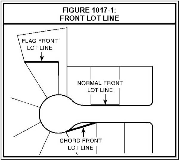
  2. FRONT LOT LINE: A lot line abutting a street.  For corner lots, the front lot line is that with the narrowest street frontage.  When the lot line abutting a street is curved, the front lot line is the chord or straight line connecting the ends of the curve.  For a flag lot, the front lot line is the lot line that is most parallel to and closest to the street, excluding the pole portion of the flag lot.  (See Figure 1017-1.) 

    Figure of Front Lot Line 
     
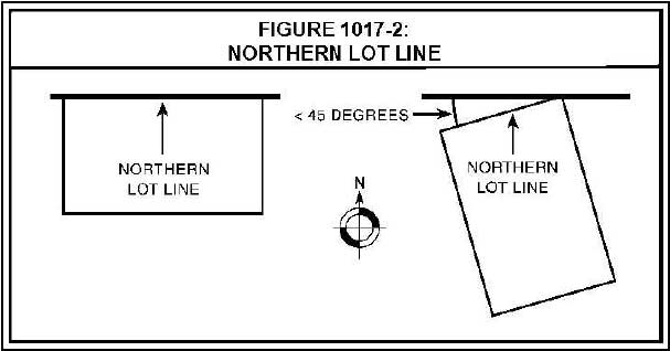
  3. NORTHERN LOT LINE: The lot line that is the smallest angle from a line drawn east-west and intersecting the northernmost point of the lot, excluding the pole portion of a flag lot.  If two lot lines have an identical angle relative to a line drawn east-west, the northern lot line shall be an east-west line 10 feet in length within the lot in the northernmost point possible.  (See Figure 1017-2.)  

    Figure of Northern Lot Line
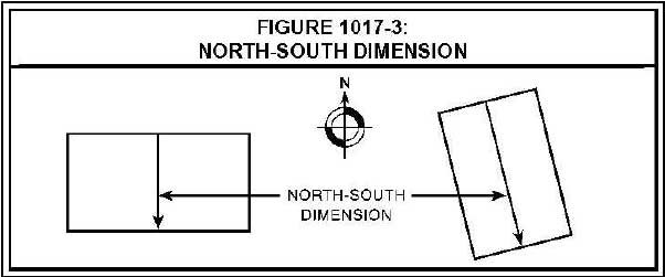
  4. NORTH-SOUTH DIMENSION: The length of a line beginning at the midpoint of the northern lot line and extending in a southerly direction perpendicular to the northern lot line until it reaches a lot line.  (See Figure 1017-3.)

     Figure of Northern Lot Line
  5. UNDEVELOPABLE AREA:  An area that cannot be used practicably for a habitable structure because of natural conditions, such as slopes exceeding 20 percent in a direction greater than 45 degrees east or west of true south, severe topographic relief, water bodies, or conditions that isolate one portion of a property from another portion so that access is not practicable to the unbuildable portion; or man-made conditions, such as right-of-way; existing development which isolates a portion of the site and prevents its further development; setbacks or development restrictions that prohibit development of a given area of a lot by law or private agreement; or existence or absence of easements or access rights that prevent development of a given area.

1017.03 Design Standard

Except as established by Subsection 1017.04, a minimum of 70 percent of the lots or parcels in the subdivision, partition, or Type II replat shall:

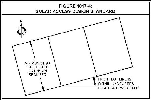
  1. Have a minimum north-south dimension of 90 feet.  Undevelopable area, other than a required setback area, may be included in the north-south dimension if it abuts either of the lot lines used in calculating north-south dimension; and
  2. Have a front lot line that is oriented within 30 degrees of a true east-west axis.  (See Figure 1017-4.)  

    Diagram of Solar Access design standard

1017.04 Exceptions to the Design Standard

The minimum percentage of lots or parcels that must comply with Subsection 1017.03 shall be reduced to the minimum extent necessary if one or more of the following site characteristics apply:

  1. Density and Cost:  If Subsection 1017.03 is applied, either the resulting density would be less than that proposed, the minimum density would be less than that required in Section 1012, Lot Size and Density, or on-site site development costs (e.g., grading, roads, and water, surface water management and sanitary sewer systems) are at least five percent more per lot or parcel than if the standard is not applied due to one of the following conditions:
    1. The subject property, or a portion of the subject property for which the exception is sought, has a natural grade that is sloped 20 percent or more and is oriented greater than 45 degrees east or west of true south, based on a topographic survey by a professional land surveyor registered in the State of Oregon.
    2. The subject property includes a significant natural feature identified in the Comprehensive Plan, designated open space identified in the Comprehensive Plan, a highly or moderately restricted area identified in Subsection 1012.05, or a protected water resource and associated vegetated corridor regulated by the surface water management authority, that:
      1. Prevents given streets, lots, or parcels from being oriented for solar access; and
      2. Will remain undeveloped.
    3. Existing road patterns must be continued through the subject property or must terminate on-site to comply with applicable road standards or planned roads in a way that prevents given streets, lots, or parcels from being oriented for solar access.
    4. An existing public easement or right-of-way prevents given streets, lots, or parcels from being oriented for solar access. 
  2. Development Amenities:  If Subsection 1017.03 is applied to a given lot or parcel, significant development amenities that would otherwise benefit the lot or parcel will be lost or impaired.  Evidence that a significant diminution in the market value of the lot or parcel would result from having the lot or parcel comply with Subsection 1017.03 is relevant to whether a significant development amenity is lost or impaired. 
  3. Existing Shade: As demonstrated by a scaled tree survey or an aerial photograph, trees a minimum of 30 feet tall, and more than six inches in diameter at a point four feet above grade, have a crown cover over at least 80 percent of a given lot or parcel, and at least 50 percent of the crown cover will remain after development of the lot or parcel.
    1. Trees are assumed to remain if the trees do not need to be removed for a driveway or other development and at least one of the following applies:
      1. The trees are in a required setback;
      2. The trees are part of an existing or proposed park, open space, or recreational amenity;
      3. The trees are separated from the developable remainder of their lot or parcel by an undevelopable area or feature; or
      4. The trees are required to be preserved pursuant to Subsection 1002.03(A).
    2. Those trees that are assumed to remain; required for compliance with the minimum crown cover standard of Subsection 1017.04(C); and located on the subject property, or contiguous property under the same ownership as the subject property, shall be preserved and protected pursuant to Subsection 1002.03.

[Amended by Ord. ZDO-253, 6/1/15; Amended by Ord. ZDO-266, 5/23/18; Amended by Ord. ZDO-268, 10/2/18]

Return to the Zoning and Development Ordinance main page. Contact zoninginfo@clackamas.us for additional information."

Sidebar Heading
Related Information
New Format?
Off

ZDO 1015: Parking and Loading

1015.01 General Standards

  1. Inside the Portland Metropolitan Urban Growth Boundary (UGB), parking, loading, and maneuvering areas shall be hard-surfaced, unless a permeable surface is required for surface water management pursuant to the regulations of the surface water management authority or in order to comply with Subsection 1006.06.
  2. Outside the UGB, areas used for parking, loading, and maneuvering of vehicles shall be surfaced with screened gravel or better, and shall provide for suitable drainage. 
  3. Parking and loading requirements for uses and structures not specifically listed in Tables 1015-1, Automobile Parking Space Requirements; 1015-2, Minimum Automobile Parking Space Requirements for Dwellings; 1015-3, Minimum Required Bicycle Parking Spaces; and 1015-4, Minimum Required Off-Street Loading Berths shall be subject to the requirements for the most similar use.
  4. Motor vehicle parking, bicycle parking, and loading areas shall be separated from one another.
  5. Required parking spaces and loading berths shall not be:
    1. Rented, leased, or assigned to any other person or organization, except as provided for under Subsection 1015.02(D)(3)(a) for shared parking or Subsection 1015.04(C) for shared loading berths.
    2. Used for storing or accumulating goods or storing a commercial or recreational vehicle, camper, or boat, rendering the space(s) useless for parking or loading operations.
    3. Occupied by the conducting of any business activity, except for permitted temporary uses (e.g., farmers' markets).

1015.02 Motor Vehicle Parking Area Standards

  1. Off-street parking areas shall be designed to meet the following requirements:
    1. Off-street motor vehicle parking areas shall be provided in defined areas of the subject property. No area shall be considered a parking space unless it can be shown that the area is accessible and usable for that purpose and has required maneuvering area for vehicles. Required backing and maneuvering areas shall be located entirely onsite.
    2. Automobile parking spaces shall be a minimum of 8.5 feet wide and 16 feet long, except that parallel spaces shall be a minimum of 8.5 feet wide and 22 feet long. 
    3. A minimum of 25 percent of required parking spaces shall be no larger than 8.5 feet wide and 16 feet long.
    4. Parking areas shall comply with minimum dimensions for curb length, stall depth, and aisle width established by the Clackamas County Roadway Standards; these dimensions are based on the orientation (e.g., 45-degree, 90-degree), length, and width of the spaces.
    5. Double-loaded, 90-degree angle parking bays shall be utilized where possible.
    6. A minimum of one parking space or five percent of the required spaces, whichever is greater, shall be marked and signed for use as carpool/vanpool spaces. These spaces shall be the closest employee automobile parking spaces to the building entrances normally used by employees, but shall not take priority over any spaces required for individuals with disabilities.
    7. In parking lots greater than one acre, major onsite circulation drive aisles and lanes crossing to adjacent developments shall not have parking spaces accessing directly onto them.
    8. Where feasible, shared driveway entrances, shared parking and maneuvering areas, and interior driveways between adjacent parking lots shall be required.
    9. Except for parallel spaces, parking spaces heading into landscaped areas or along the perimeter of a parking lot shall be provided with a sturdy tire stop at least four inches high and located two feet within the space to prevent any portion of a car within the lot from extending over the property line.
    10. For parking spaces heading into a landscaped area, the area in front of the tire stop that is included in the parking space dimension may be landscaped instead of paved or graveled according to the following standards:
      1. Landscaping shall be ground cover plants only;
      2. The area in front of the tire stop that is included in the parking space dimension shall be in addition to the required minimum dimension for a landscape planter; and
      3. The landscaped area in front of the tire stop may count toward overall site landscaping requirements established in Table 1009-1, Minimum Landscaped Area. However, it may not count toward perimeter landscaping requirements established in Section 1009.03(B)(1). 
  2. Parking Minimums: The minimum number of parking spaces listed in Tables 1015-1, Automobile Parking Space Requirements, and 1015-2, Minimum Automobile Parking Space Requirements for Dwellings, applies unless modified in Subsection 1015.02(D). 
    1. In case of expansion of a building or use that, prior to the expansion, does not meet the minimum parking space requirements in Table 1015-1 or 1015-2, the following provisions shall apply:
      1. The minimum number of additional parking spaces required shall be based only on the floor area or capacity added and not the area or capacity existing prior to the expansion.
      2. If the enlargement covers any of the pre-expansion parking spaces, lost parking spaces shall be replaced, in addition to any required additional spaces.
    2. In the event more than one use occupies a single structure or parcel, the total minimum requirement for parking shall be the sum of the minimum requirements of the several uses computed separately. 
  3. Parking Maximums:
    1. Within the UGB, the parking maximums listed for Urban Zone A in Table 1015-1 and Note 4 of Table 1015-2 apply when an area has 20-minute peak hour transit service within one-quarter mile walking distance for bus transit or one-half mile walking distance for light rail transit.
    2. Within the UGB, areas not meeting the requirements of Subsection 1015.02(C)(1), are subject to the parking maximums listed in Table 1015-1, Urban Zone B.
    3. In case of expansion of a building or use with more parking spaces than the maximumallowed by Table1015-1
      1. Existing parking spaces may be retained, replaced, or eliminated, provided that after the expansion, the total number of remaining spaces complies with the minimum parking space requirement of Table 1015-1 for the entire development; and
      2. Additional parking spaces are allowed only if required to comply with the minimum parking space requirement of Table 1015-1 for the entire development after the expansion.

Table 1015-1: Automobile Parking Space Requirements1

Land Use CategoryMinimum Parking SpacesMaximum Parking Spaces (Urban Zone A)Maximum Parking Spaces (Urban Zone B)
Amusement Parks, Riding Academies, and Camps (per 1000 square feet of serving area)0.8NoneNone
Bank with Drive-in4.35.46.5
Bed and Breakfast Residences and Inns1 for each guest room and 1 for the operatorNoneNone
Bowling Alleys (per alley)3NoneNone
Child Care Facilities0.5 
In addition, a passenger-loading area shall be provided on the site. 
NoneNone
Dwellings (see Table 1015-2)   
Home Occupations for Canine Skills Training1 per canine handler, based on the maximum number of handlers permitted for any single training session. An additional space shall be provided for each employee.NoneNone
Home Occupations to Host Events1 space per 3 guests based on the maximum number of guests permitted for any single event. An additional space shall be provided for each employee.NoneNone
Hospitals0.5NoneNone
Hotels and Motels (per unit)1NoneNone
Industrial, Manufacturing, and Processing Facilities   
Zero to 24,999 square feet1.5NoneNone
25,000 to 49,999 square feet1.42NoneNone
50,000 to 79,999 square feet1.25NoneNone
80,000 square feet and greater1NoneNone
Medical and Dental Clinics3.54.95.9
Movie Theaters (per seat)0.30.40.5
Nursing Homes, Welfare or Correctional Institutions, and Institutions for Children (per bed)0.2NoneNone
Office Uses (includes Office Park, "Flex-Space", Government Office and Miscellaneous Services)2.73.44.1
Places of Worship (per seat located in main assembly room, or 1 per 100 sq. ft. in main assembly room, exclusive of chancel or stage).
If a school, child care facility, or similar facility is proposed in conjunction with primary use, it shall have separate parking requirement.
0.250.60.8
Produce Stands (per stand)4NoneNone
Recreational Vehicle Camping Facilities1 per campsite (in addition to the space required for parking the recreational vehicle) and 1 per employee at peak employment periodNoneNone
Restaurants: Fast Food with drive-thru window service9.012.414.9
Restaurants: With no drive-thru window service, Taverns15.019.123
Retail/Commercial, including shopping centers4.1,
except in the Clackamas Regional Center Area, 3.0
5.16.2
Retail stores with bulky merchandise, such as furniture, appliances, automobiles, service/repair shops 25.16.2
Schools: Colleges, Universities, and High Schools (per student or staff member)0.20.30.3
Schools: Elementary and Junior High Schools (per school)15, or 2 per classroom, whichever is lessNoneNone
Service Stations (per employee at peak employment period)1NoneNone
Sports Clubs/Recreation Facilities4.35.46.5
Surface MiningOn-site vehicular parking for employees, customers and visitors, determined through Conditional Use process.NoneNone
Tennis and Racquetball Courts11.31.5
Theaters, Dance Halls, Community Clubs, Skating Rinks, Public Meeting Places (per seat, or 1 per 100 sq. ft. exclusive of stage)0.25NoneNone
Warehouse and Storage Distribution, and Terminals (air, rail, truck, water, etc.) **Maximum parking requirements apply only to warehouses 150,000 gross square feet or greater.   
Zero to 49,999 square feet0.3NoneNone
50,000 square feet and over0.20.4**0.5**

1Parking requirements are expressed as number of spaces per 1,000 square feet of gross leasable area, unless otherwise stated.

Table 1015-2: Minimum Automobile Parking Space Requirements for Dwellings1

Dwelling TypeZoning District: R-5 – R-30Zoning District: VR-4/5 & VR-5/7Zoning District: VTHZoning District: MR-1 & MR-2Zoning District: SCMUZoning District: HR2Zoning District: MRRZoning District: RA-1 & RA-2All Other Zoning Districts
Accessory Dwelling Unit000N/AN/A1100
Accessory Historic DwellingN/AN/AN/AN/AN/AN/AN/A00
Congregate Housing Facility (per resident)N/AN/A0.250.250.25N/A0.25N/A0.25
Cottage Cluster11N/AN/AN/AN/AN/AN/A0
Detached Single-Family Dwelling or Manufactured Dwelling (located on an individual lot)1, located behind the front setback line1, located behind the front setback lineN/AN/AN/A1 per dwelling unit 800 square feet or less
2 per dwelling unit greater than 800 square feet
1 per 600 square feet of residential building area1, located behind the front setback line0
Duplex or Triplex13131.51.51.5N/A1 per 600 square feet of residential building area Duplex in RA-1: 1.51.5
All others: N/A         
Manufactured Dwelling (located in a manufactured dwelling park)2N/AN/A2, if located in MR-1N/AN/A2N/A2
N/A, if located in MR-2         
Multifamily Dwelling:
 Per studio/zero-bedroom or one-bedroom dwelling unit
N/AN/AN/A11N/A1N/A1
Per two-bedroom dwelling unitN/AN/AN/A1.251.25N/A1.25N/A1.25
Per three-bedroom dwelling unitN/AN/AN/A1.51.5N/A1.5N/A1.5
Quadplex1313Same as multifamily dwelling in all other zoning districtsSame as multifamily dwellingSame as multifamily dwellingN/ASame as multifamily dwellingN/ASame as multifamily dwelling
Townhouse111, located in a garage2141 per dwelling unit 800 square feet or less
2 per dwelling unit greater than 800 square feet
1 per 600 square feet of residential building areaN/A15

1Minimum parking requirement is expressed as number of spaces per dwelling unit, unless otherwise stated. N/A means the dwelling type is not allowed in the applicable zoning district.

2On land above 3,500 feet in elevation, covered parking shall be provided for structures containing three or more dwelling units.

3No additional parking spaces shall be required for conversion of a detached single-family dwelling to middle housing.

4The parking exception in Subsection 1015.02(D)(3)(b) does not apply to townhouses. Maximum parking for townhouses in Urban Zone A is two spaces per townhouse.

5In the R-2.5 District, the required parking shall be located behind the front setback line.

  1. Exceptions to Parking Requirements:
    1. Parking maximums in Table 1015-1 and Note 4 to Table 1015-2 may be increased for the following:
      1. Parking spaces in parking structures;
      2. Fleet parking spaces;
      3. Designated employee carpool spaces;
      4. User-paid spaces; and
      5. Parking spaces for vehicles for sale, lease, or rent.
    2. Parking minimums in Table 1015-2 may be reduced by 40 percent for multifamily dwelling units on sites within a one-quarter mile walking distance of a light rail station. Walking distance is measured along public roads, walkways, or accessways.
    3. Parking minimums in Tables 1015-1 and 1015-2, or as calculated pursuant to Subsection 1015.02(D)(2), may be reduced for the following:
      1. The total minimum requirement for parking spaces may be reduced up to 20 percent per use when shared parking is utilized. 
      2. In commercial and industrial zoning districts, available permitted on-street parking spaces on a development's street frontage may be counted toward required parking. To count as an on-street parking space, the space must comply with the minimum dimensions for a parking space established by Subsections 1015.02(A)(2) and (4).
      3. Motorcycle parking may substitute for required automobile parking spaces as follows: 
        1. Up to five spaces or five percent of required automobile parking, whichever is less, may be utilized. 
        2. For every four motorcycle parking spaces provided, the automobile parking requirement is reduced by one space. 
        3. Each motorcycle space must be at least four feet wide and eight feet deep. 
      4. Electric vehicle charging stations may be installed according to the following standards:
        1. Two spaces or five percent of the minimum required parking spaces, whichever is greater, may be utilized for electric vehicle charging stations and identified exclusively for such use. 
        2. Additional parking spaces of the minimum required parking may be utilized for electric vehicle charging stations, provided they are not identified exclusively for such use.
        3. Any portion of parking spaces provided that are beyond the required minimum number of parking spaces may be utilized for electric vehicle charging stations, regardless of whether they are identified exclusively for such use. 
    4. A parking cap applies in the SCMU District. The total number of parking spaces provided for nonresidential development (either onsite or offsite) shall not exceed the parking cap, regardless of the number of pre-existing parking spaces. Parking maximums and minimums established by Tables 1015-1 and 1015-2 shall be adjusted to the extent necessary to comply with the parking cap. The parking cap shall be calculated by the following formula:
Parking Cap = Gross Acres of the Development Site x 67 Parking Spaces

1015.03 Bicycle Parking Standards

  1. Bicycle parking areas shall meet the following on-site locational requirements:
    1. Bicycle parking racks shall be located in proximity to an entrance but shall not conflict with pedestrian needs.
    2. At least 75 percent of the bicycle parking spaces shall be located within 50 feet of a public entrance to the building. 
    3. Bicycle parking may be provided within a building, if the location is easily accessible for bicycles. 
    4. Bicycle parking for multiple uses, or a facility with multiple structures, may be clustered in one or several locations within 50 feet of each building's entrance.
    5. If the bicycle parking is not easily visible from the street or main building entrance, then a sign must be posted near the building entrance indicating the location of the parking facilities. 
  2. Bicycle parking shall be designed to meet the following requirements:
    1. When more than seven bicycle parking spaces are required, a minimum of 50 percent of the spaces shall be covered. All of the required bicycle spaces for schools, park-and-ride lots, congregate housing facilities, quadplexes, and multifamily dwellings shall be covered.
    2. Cover for bicycle parking may be provided by building or roof overhangs, awnings, bicycle lockers, bicycle storage within buildings, or freestanding shelters. 
    3. When more than 15 covered bicycle parking spaces are required, 50 percent of the required covered spaces shall be enclosed and offer a high level of security, e.g., bicycle lockers or a locked cage or room with locking facilities inside, to provide safe long-term parking.
    4. Required bicycle parking spaces shall be illuminated.
    5. Required bicycle parking areas shall be clearly marked and reserved for bicycle parking only.
    6. Bicycle parking space dimensions and standards:
      1. Bicycle parking spaces must be at least six feet long and two feet wide, and in covered situations the overhead clearance must be at least seven feet. 
      2. An aisle a minimum of five feet wide must be provided for bicycle maneuvering. 
      3. Bicycle racks must hold bicycles securely by the frame and be securely anchored.
      4. Hanging bicycle racks and/or enclosed, stackable bike lockers may be substituted for surface racks if comparable dimensions, maneuvering, and clearance are provided to the user.
      5. Bicycle racks must accommodate both: 
        1. Locking the frame and one wheel to the rack with a high-security U-shaped shackle lock; and
        2. Locking the frame and both wheels without removal of wheels to the rack with a chain or cable not longer than six feet. 
    7. The minimum number of bicycle parking spaces listed in Table 1015-3, Minimum Required Bicycle Parking Spaces, are required.  If a listed use is located with the Portland Metropolitan Urban Growth Boundary (UGB), it shall have a minimum of two bicycle parking spaces or the number required by Table 1015-3, whichever is greater.
    8. Within the UGB, quadplexes not developed pursuant to Section 845, Triplexes, Quadplexes, Townhouses, and Cottage Clusters, and multifamily residential, commercial, and institutional developments shall designate short-term bicycle parking (less than four hours) and long-term bicycle parking (four or more hours) spaces as needed for the development.

Table 1015-3: Minimum Required Bicycle Parking Spaces

Land Use CategoryMinimum Bicycle Parking Spaces1
Elementary Schools, Junior High Schools, Middle Schools, Senior High Schools, and Colleges (per classroom)2
(maximum required spaces – 100)
Quadplexes not approved pursuant to Section 845 and Multifamily Dwellings (per dwelling unit)0.5
Park-and-Ride Lots, Transit Centers, and Community Parks (per acre)5
Preschools4
Residential Care Facilities, Nursing Homes, and Hospitals (per 8 beds)1
Retail and Commercial including offices and clinics 
Per 2,500 square feet, up to 50,000 square feet1
Per each additional 5,000 square feet1
Theaters, Places of Worship, Auditoriums, Dance Halls and other Public Assembly Places (per 40 seats or per 40 persons of design capacity, whichever is greater)1
Warehouses and industrial buildings without attached offices, automotive service uses such as service stations and tire stores, and businesses selling large items such as major appliances, furniture, cars, or boats (per 10,000 square feet of building area)1

1Minimums outside the UGB are 20 percent of the requirement listed in Table 1015-3.

1015.04 Off-Street Loading Standards

  1. No area shall be considered a loading berth unless it can be shown that the area is accessible and usable for that purpose, and has maneuvering area for vehicles.
  2. In cases of expansion of a building or use, that prior to the expansion, does not meet the minimum loading berth requirements in Table 1015-4, Minimum Required Off-Street Loading Berths, the following provisions shall apply:
    1. The minimum number of additional loading berths required shall be based only on the floor area or capacity added and not on the area or capacity existing prior to the expansion.
    2. If the expansion covers any pre-expansion loading berths, lost loading berths shall be replaced, in addition to any required additional berths.
  3. In the event several uses occupy a single structure or parcel of land and share the same loading berths, the total requirement for off-street loading shall be reduced by up to 25 percent of the sum of the requirements of the several uses computed separately.
  4. The minimum off-street loading berths listed in Table 1015-4 are required.

Table 1015-4: Minimum Required Off-Street Loading Berths

Land Use CategoryUnit of MeasurementNumber of Loading BerthsMinimum Required Dimension
Multifamily DwellingsNumber of Dwelling Units 25 feet x 12 feet x 14 feet high
 Below 50None 
 50 to 1001 
 101 to 2002 
 201 or more3 
Hotels and MotelsSquare feet of floor area 35 feet x 12 feet x 14 feet high
 Under 5,000None 
 5,000 to 50,0001 
 50,001 to 150,0002 
 150,001 to 300,0003 
 300,001 to 500,0004 
 For each additional 200,0001 additional berth 
Land Use CategoryUnit of MeasurementNumber of Loading BerthsMinimum Required Dimension
Institutional Uses   
Nursing Homes, Welfare or Correctional Institutions, and Institutions for ChildrenNumber of beds 35 feet x 12 feet x 14 feet high
 Less than 250 
 More than 251 
Assisted Living FacilitiesSquare feet of floor area  
 Below 10,000None 
 10,000 to 60,0001 
 60,001 to 160,0002 
 160,001 to 264,0003 
 388,001 to 520,0005 
 520,001 to 652,0006 
 652,001 to 784,0007 
 784,001 to 920,0008 
 For each additional 140,0001 additional berth 
SchoolsPer each school bus0.5 
Land Use CategoryUnit of MeasurementNumber of Loading BerthsMinimum Required Dimension
HospitalsSquare feet of floor area 35 feet x 12 feet x 14 feet high
 Under 5,000None 
 5,000 to 16,0001 
 16,001 to 40,0002 
 40,001 to 64,0003 
 64,001 to 96,0004 
 96,001 to 128,0005 
 128,001 to 160,0006 
 160,001 to 196,0007 
 For each additional 36,0001 additional berth 
Commercial UsesSquare feet of floor area 35 feet x 12 feet x 14 feet high
 Under 5,000None 
 5,000 to 24,9991 
 25,000 to 49,9992 
 50,000 to 100,0003 
 Each additional 50,0001 
Land Use CategoryUnit of MeasurementNumber of Loading BerthsMinimum Required Dimension
Industrial, Manufacturing, Warehousing, Storage, Processing, and TerminalsSquare feet of floor area 60 feet x 12 feet x 14 feet high
 Under 5,000None 
 5,000 to 16,0001 
 16,001 to 40,0002 
 40,001 to 64,0003 
 64,001 to 96,0004 
 96,001 to 128,0005 
 128,001 to 160,0006 
 160,001 to 196,0007 
 For each additional 36,0001 additional berth 

[Added by Ord. ZDO-224, 5/31/11; Amended by Ord. ZDO-231, 1/31/12; Amended by Ord. ZDO-243, 9/9/13; Amended by Ord. ZDO-246, 3/1/14; Amended by Ord. ZDO-250, 10/13/14; Amended by Ord. ZDO-252, 6/1/15; Amended by Ord. ZDO-266, 5/23/18; Amended by Ord. ZDO-269, 9/6/18; Amended by Ord. ZDO-268, 10/2/18; Amended by Ord. ZDO-276, 10/1/20; Amended by Ord. ZDO-277, 1/1/22; Amended by Ord. ZDO-282, 7/1/22; Amended by Ord. ZDO-287, 8/3/23]

Return to the Zoning and Development Ordinance main page. Contact zoninginfo@clackamas.us for additional information."

Sidebar Heading
Related Information
New Format?
Off

ZDO 1013: Planned Unit Developments

1013.01 Applicability

Section 1013 applies to subdivisions, partitions, and replats as follows:

  1. A subdivision, partition, or replat may be developed as a planned unit development in residential, commercial, and industrial zoning districts, except the FU-10 District. 
  2. In an Urban Low Density Residential, MRR, or HR District, a subdivision, partition, or Type II replat shall be developed as a planned unit development if the subject property is larger than one acre and at least 10 percent of the subject property is designated Open Space on Comprehensive Plan Map IV-6, North Urban Area Land Use Plan Map; X-MH-1, Resource Protection Open Space; X-MH-2, Resource Protection Open Space; X-MH-3, Resource Protection Open Space; or X-MH-5, Government Camp Village Plan Resource Protection Open Space.

1013.02 Accessory Uses

The following accessory uses are permitted in a planned unit development.  As used in Subsection 1013.02, accessory use means a subordinate use, the function of which is clearly incidental to that of the main use(s) in the planned unit development.

  1. Recreational uses, such as bicycle trails, golf courses, nature preserves, playgrounds, recreation rooms, swimming pools, tennis courts, walking trails, and wildlife sanctuaries; and
  2. Offices, other buildings, and facilities required for:
    1. The operation, administration, and maintenance of the planned unit development;
    2. Recreational uses permitted pursuant to Subsection 1013.02(A); and
    3. Vehicle parking and storage established pursuant to Subsection 1013.03(D)

1013.03      Dimensional and Development Standards

  1. Natural or Unique Features:  To the maximum extent feasible, the plan and design of the planned unit development shall ensure that natural or unique features of the land and environment are preserved.
  2. Maximum Number of Lots:  In the RA-2, RR, RRFF-5, and FF-10 Districts, the number of residential lots in a planned unit development shall not exceed 10.
  3. Open Space:
    1. A minimum of 20 percent of the gross site area shall be platted as one or more open space tracts.
    2. Open space tracts may include recreational uses permitted pursuant to Subsection 1013.02(A), bicycle trails, walking trails, natural or landscaped buffer areas, bus shelters, and significant natural vegetation or landscape features. 
    3. Open space tracts shall not include:
      1. Parking areas or driveways, except those serving recreational uses permitted pursuant to Subsection 1013.03(C)(2) ; or
      2. Roads.
    4. The PUD shall be designed so that no lot or parcel is located more than 1000 feet from an open space tract.
    5. All lots or parcels within the PUD shall have reasonable access to at least one open space tract.
    6. Each open space tract shall be large enough for recreational use unless the open space is intended to protect significant natural features from impacts associated with use or development. 
    7. The open space restrictions shall continue in perpetuity, unless the restrictions are modified pursuant to either Section 1309, Modification, or the approval of a new land use permit application provided for by this Ordinance. 
  4. Parking:  The following may be required after consideration of street type, width, traffic volume, transit amenities, and pedestrian circulation:  guest parking for dwellings and sufficient parking space for storage of residents' recreational vehicles.
    1. If required, recreational vehicle parking shall be located so as to be compatible with the surrounding development.  If located on the perimeter of the PUD, it shall be screened from adjacent properties.
    2. Off-street parking may be provided on each lot or parcel or in parking areas in proximity to the dwellings they serve, provided that such common parking areas shall be developed on a platted tract designated for parking.

[Amended by Ord. ZDO-248, 10/13/14; Amended by Ord. ZDO-252, 6/1/15; Amended by Ord. ZDO-253, 6/1/15; Amended by Ord. ZDO-266, 5/23/18; Amended by Ord. ZDO-283, 9/5/23]

Return to the Zoning and Development Ordinance main page. Contact zoninginfo@clackamas.us for additional information."

Sidebar Heading
Related Information
New Format?
Off

ZDO 1012: Lot Size and Density

1012.01 Applicability

Section 1012 applies to the following land use permit applications in any zoning district that has a minimum lot size standard, district land area standard, or minimum density standard, except the AG/F, EFU, and TBR Districts:

  1. Subdivisions;
  2. Partitions;
  3. Replats reviewed as a Type II application pursuant to Section 1307, Procedures;
  4. Design review for manufactured home parks, congregate housing facilities, and dwellings, including residential condominiums; and
  5. Conditional uses for manufactured home parks and dwellings.

1012.02 Minimum Lot Size Exceptions

In subdivisions, partitions, and replats, lots and parcels shall comply with the minimum lot size standards, if any, of the applicable zoning district, except as established by Subsections 1012.02(A) through (I).

  1. Limitation: Notwithstanding Subsections 1012.02(C) through (F), the minimum lot size inside the Portland Metropolitan Urban Growth Boundary is 20 acres in the FF-10, RA-1, RA-2, RC, RI, and RRFF-5 Districts, except as provided by Subsection 3.07.1130(c) of the Code of the Metropolitan Service District.
  2. Bonus Density: If a smaller lot size is necessary to provide bonus density dwelling units awarded under Subsection 1012.05(E), the minimum lot size standard of the applicable zoning district is waived. Demonstrating compliance with this standard shall not require the proposed development to be a planned unit development or require that townhouses be developed.
  3. Two or More Lawfully Established Dwellings on One Lot of Record: If a lot of record is not large enough to be divided in compliance with the minimum lot size standard of the applicable zoning district, the standard is waived if there are two or more lawfully established dwellings located on one lot of record with a Comprehensive Plan land use plan designation of Low Density Residential, Unincorporated Community Residential, or Rural. At least one of the lawfully established dwellings shall be located on each lot or parcel created pursuant to Subsection 1012.02(C). Subsection 1012.02(C) does not apply to the creation of separate lots or parcels for:
    1. Accessory dwelling units;
    2. Accessory historic dwellings;
    3. Accessory farm dwellings on a lot of record with a land use plan designation of Rural if the accessory farm dwelling was established after October 4, 2000;
    4. Manufactured dwellings and residential trailers established under a temporary permit;
    5. Manufactured dwellings and residential trailers established within a manufactured dwelling park or a manufactured home park;
    6. Dwellings established as a "replacement" for a historic landmark dwelling, where the continued use of the historic landmark dwelling for residential purposes was permitted as a conditional use in the HL, HD, or HC overlay zoning district; or
    7. Middle housing dwelling units; however, middle housing land divisions are permitted pursuant to Section 1105, Subdivisions, Partitions, Replats, Middle Housing Land Divisions, Condominium Plats, and Vacations of Recorded Plats.
  4. Conditional Use: If the subject property is developed, or approved to be developed, with a conditional use, the minimum lot size standards of the applicable zoning district are waived, provided:
    1. If a minimum lot size for the conditional use is established by Section 800, Special Use Requirements, it remains applicable.
    2. The proposed lot size requires approval pursuant to Section 1203, Conditional Uses. However, approval pursuant to Section 1203 does not waive the requirement to also receive approval pursuant to Section 1105, Subdivisions, Partitions, Replats, Condominium Plats, and Vacations of Recorded Plats.
    3. The minimum lot size waiver applies only to a lot or parcel developed with the conditional use and not to any other lots or parcels in the proposed subdivision, partition, or replat.
    4. A deed restriction limiting development of an undersized lot or parcel to the approved conditional use shall be recorded in conjunction with the recording of the final plat.
    5. This lot size exception does not apply in the RA-2 or RR Districts, and the minimum lot size for the lot or parcel developed with the conditional use is two acres in the RRFF-5 and FF-10 Districts. In addition, duplexes in the RA-1 District are subject to Subsection 1012.02(F) in lieu of Subsection 1012.02(D).
  5. Comprehensive Plan Boundary: If through a Type IV Comprehensive Plan map amendment, a lot of record is divided by a Comprehensive Plan land use plan designation boundary, the lot of record may be partitioned along that boundary (access strips and parcels of less than one acre are excluded). If the boundary separates an Agriculture or Forest designation from an Urban, Unincorporated Community, or Rural designation, or if the boundary separates an Agriculture designation from a Forest designation, the exception to the minimum lot size standards does not apply to any portion of the subject property designated Agriculture or Forest, except to the extent that Subsection 401.08(K) or 406.09(G) also applies.
  6. Duplexes in the RA-1 District: In the RA-1 District, there is no minimum lot size for a lot or parcel to be developed with duplexes pursuant to Section 1203, Conditional Uses. However, the maximum density standards of Subsection 1012.07 apply to the entire property proposed for development with duplexes prior to the creation of new lots or parcels.
  7. Townhouses: In the R-5, R-7, R-8.5, R-10, R-15, R-20, R-30, VR-4/5, or VR-5/7 District, the minimum lot size standards are waived for townhouses.
  8. Middle Housing Land Divisions: In the R-5, R-7, R-8.5, R-10, R-15, R-20, R-30, VR-4/5, or VR-5/7 District, the minimum lot size standards are waived for middle housing land divisions approved pursuant to Section 1105, Subdivisions, Partitions, Replats, Middle Housing Land Divisions, Condominium Plats, and Vacations of Recorded Plats.
  9. Nonresidential Tracts: The minimum lot size standards are waived for a designated nonresidential tract for a private road, open space, or similar support purpose.

1012.03 Maximum Lot Size

In subdivisions, partitions, and replats in the VR-5/7, VR-4/5, and VTH Districts, lots and parcels shall comply with the maximum lot size standards of the applicable zoning district, except as established by Subsections 1012.03(A) through (C) for the VR-5/7 and VR-4/5 Districts.

  1. A portion of the subject property may be excluded when calculating average lot size for the subdivision, partition, or replat pursuant to Note 4 or 5 of Table 315-3, Dimensional and Building Design Standards in the VR-5/7, VR-4/5, and VTH Districts, or when calculating maximum individual lot size, provided that a master plan for the excluded portion of the subject property demonstrates that the maximum lot size standards can be met for the entire property through future land division.
  2. Unless a master plan is provided pursuant to Subsection 1012.03(A), the maximum size of a lot or parcel created for a dwelling lawfully established prior to being zoned VR-5/7 or VR-4/5 is 15,000 square feet unless the dwelling is in a resource protection area, as shown on Comprehensive Plan Map X-SV-1, Sunnyside Village Plan Land Use Plan Map, in which case there is no maximum lot size standard. Such a lot or parcel is excluded when calculating average lot size for the subdivision, partition, or replat pursuant to Note 4 or 5 of Table 315-3.
  3. Resource protection area, as shown on Comprehensive Plan Map X-SV-1, is excluded when calculating average lot size for the subdivision, partition, or replat pursuant to Note 4 or 5 of Table 315-3 or when calculating maximum individual lot size.

1012.04 General Density Provisions

  1. Density is a measurement of the number of dwelling units in relationship to a specified amount of land. In the context of a partition, subdivision, replat, or manufactured home park, density typically relates to potential dwelling units in the form of lots, parcels, or manufactured home park spaces. Density often is expressed as dwelling units per acre; however, this Ordinance implements density standards in many zoning districts by assigning a district land area (DLA), which is the starting point for determining the maximum number of dwelling units allowed on a particular site. In general, the DLA is the minimum lot area required per dwelling unit; however, the DLA is subject to adjustment for density bonuses, restricted area development limitations, and limits on the extent of new road area that must be subtracted. In addition, for a duplex, triplex, quadplex, or cottage cluster in the R-5, R-7, R-8.5, R-10, R-15, R-20, R-30, VR-4/5, or VR-5/7 District, and for accessory dwelling units, DLA is not the minimum lot area required per dwelling unit.
  2. The DLA and the minimum lot size standard applicable to a particular zoning district are seldom the same. Often this is because the maximum density derived from the DLA standard is calculated over the entire site prior to any platting of new lots or parcels. The minimum lot size standard then typically permits flexibility in determining where on the site the allowed dwelling units will be developed. For example, some lots may be relatively large while others are smaller, or open space tracts may be platted while all lot sizes are relatively small. Regardless of allowed flexible sizing of individual lots or parcels, however, the maximum density allowed for the entire site remains the same.
  3. Except for middle housing land divisions approved pursuant to Section 1105, Subdivisions, Partitions, Replats, Middle Housing Land Divisions, Condominium Plats, and Vacations of Recorded Plats, if the subject property is currently developed with one or more dwelling units that will be retained, such dwelling units shall be included in demonstrating compliance with the maximum and minimum density standards of Section 1012. Notwithstanding this provision, accessory dwelling units and temporary dwellings approved pursuant to Section 1204, Temporary Permits, are not included in demonstrating compliance with the density standards, provided that these dwellings will continue to comply with the requirements for accessory dwelling units or temporary dwellings, respectively.
  4. If a subdivision, partition, or replat is proposed on property currently developed with duplexes, triplexes, quadplexes, or multifamily dwellings (or with a current design review approval for such development), maximum and minimum density shall be calculated separately for each proposed lot or parcel, except:
    1. In a planned unit development or a development of duplexes approved pursuant to Subsection 1012.07, maximum and minimum density shall be calculated for the entire property proposed for development prior to the creation of new lots or parcels.
    2. Middle housing land divisions approved pursuant to Section 1105 are exempt.
  5. In a zoning district that does not allow new detached single-family dwellings, a lot created for a nonconforming detached single-family dwelling shall not be included in the gross site area used to calculate minimum and maximum density for the remaining lot(s).
  6. Except in Urban Low Density Residential, VR-4/5, and VR-5/7 Districts, each unit in a single room occupancy is considered a dwelling unit for the purposes of calculating minimum and maximum density.

1012.05 Maximum Density

If this Ordinance establishes a district land area (DLA) for the applicable zoning district, the proposed development shall be limited to a maximum density. Except as necessary to implement a minimum lot size exception granted pursuant to Subsection 1012.02 or as established by Subsection 1012.06, maximum density shall be calculated as follows.

  1. Calculate the land area of the subject property. The result is gross site area (GSA).
  2. Subtract the following from GSA to determine net site area (NSA). In the event of an overlap between categories requiring a subtraction, the area of overlap shall be classified in the most restrictive category.
    1. The land area of new county, public, or private roads (NR) in the HR, MRR, Urban Low Density Residential, VR-4/5, VR-5/7, and VTH Districts, except:
      1. If NR exceeds 15 percent of the GSA, only 15 percent of the GSA shall be subtracted.
      2. No subtraction shall be made for strips of land adjacent to existing road rights-of-way when such strips are required to be dedicated as a condition of approval;
    2. In a zoning district other than HR and MRR, any land area of the GSA in the following highly restricted areas (HRA), except that no subtraction shall be made for HRA that will remain undeveloped, in which case density accruing to these areas may be transferred to unrestricted areas:
      1. Slopes greater than 50 percent;
      2. Mass movement hazards regulated by Section 1003, Hazards to Safety;
      3. The floodway of the Floodplain Management District regulated by Section 703, Floodplain Management District;
      4. The Willamette River and the required buffer area regulated by Section 705, Willamette River Greenway;
      5. Habitat Conservation Areas regulated by Section 706, Habitat Conservation Area District (HCAD); and
      6. Water Quality Resource Areas regulated by Section 709, Water Quality Resource Area District; and
    3. In a zoning district other than HR and MRR, fifty percent of the land area of any portions of the GSA in the following moderately restricted areas (MRA), except that no subtraction shall be made for MRA that will remain undeveloped, in which case density accruing to these areas may be transferred to unrestricted areas.:
      1. Slopes equal to or greater than 20 percent and less than or equal to 50 percent; and
      2. Areas outside the floodway but within the Floodplain Management District regulated by Section 703.
    4. In the HR and MRR Districts, any land area of the GSA in the following highly restricted area (HRA). Residential development is prohibited in the HRA.
      1. The Floodplain Management District regulated by Section 703; and
    5. In the HR and MRR Districts, 50 percent of the land area of the GSA in the following moderately restricted areas (MRA). Residential development is prohibited in the MRA.
      1. Slopes greater than 25 percent;
      2. Mass movement hazards regulated by Section 1003; and
      3. Wetlands and required buffer areas regulated by Subsection 1002.06 or another public agency.
    6. In the HR and MRR Districts, although no subtraction is required for stream corridor areas, residential development is prohibited in these areas.
  3. Divide the NSA by the DLA of the applicable zoning district. The result is base density (BD). The calculations that result in a determination of BD are represented by the following formula:

    {GSA – [NR + HRA + (MRA x 0.5)]} / DLA = BD*

    * Except in the HR and MRR Districts, HRA and MRA may be reduced to zero as provided by Subsections 1012.05(B)(2) and (3).
  4. In the MRR District, the calculation in Subsection 1012.05(C) shall be done separately for each proposed unit size category identified in Table 317-3, District Land Area Standards in the MRR District. This requires the applicant to identify the square footage of the NSA that is attributed to each unit size category. The results of each separate calculation shall be added to determine BD.
  5. Add any applicable density bonuses to BD. Bonus density shall be allowed subject to the following criteria:
    1. Unless using the affordable housing bonus under option 1 in Table 1012-1, Bonus Density, the proposed development shall include a minimum of four dwelling units, excluding accessory dwelling units and temporary dwellings approved pursuant to Section 1204, Temporary Permits.
    2. The bonus density categories and corresponding maximum increases to BD, as well as the zoning districts to which the bonus density categories are applicable, are identified in Table 1012-1, Bonus Density.
    3. In the MRR District, dwelling units allowed through the bonus density provisions shall be developed with the same unit size mixture as provided in the BD. For example, if a development is proposed with a BD of 50 units of 700 square feet and 50 units of 500 square feet, and a bonus density of 10 units is allowed, the 10 bonus units shall include 5 units of 700 square feet and 5 units of 500 square feet.

Table 1012-1: Bonus Density

Bonus CategoryMaximum Increase in the HR and Urban Low Density Residential DistrictsMaximum Increase in All Other Zoning Districts
Affordable Housing: One of the following two options:  
(1) For a development inside the Portland Metropolitan Urban Growth Boundary, in which:
(a) Each unit on the property is made available to own or rent to families with incomes of 80 percent or less of the area median income (AMI) as defined by the U.S. Department of Housing and Urban Development;
(b) The average of all units on the property is made available to families with incomes of 60 percent or less of AMI; or
(c) A manufactured dwelling park is operated that serves only households with incomes of 120 percent or less of AMI; and
(d) Whose affordability, including affordability under a covenant as described in ORS 456.270 to 456.295, is enforceable for a duration of no less than 30 years.

(A) For property with existing maximum density of 16 or fewer units per acre, up to 100 percent of base density and 12 additional feet in maximum height;

(B) For property with existing maximum density of 17 or more units per acre and 45 or fewer units per acre, up to 50 percent of base density and 24 additional feet in maximum height; or

(C) For property with existing maximum density of 46 or more units per acre, up to 25 percent of base density and 36 additional feet in maximum height.

(A) For property with existing maximum density of 16 or fewer units per acre, up to 100 percent of base density and 12 additional feet in maximum height;

(B) For property with existing maximum density of 17 or more units per acre and 45 or fewer units per acre, up to 50 percent of base density and 24 additional feet in maximum height; or

(C) For property with existing maximum density of 46 or more units per acre, up to 25 percent of base density and 36 additional feet in maximum height.

(2): In any development, for dwelling units affordable to households with incomes of 80 percent or less of the area median income (AMI) as defined by the U.S. Department of Housing and Urban Development, adjusted for household size, and whose affordability, including affordability under a covenant as described in ORS 456.270 to 456.295, is enforceable for a duration of no less than 30 years.One dwelling unit per affordable dwelling unit up to 5 percent of the base densityOne dwelling unit per affordable dwelling unit up to 50 percent of the base density1
Mixed-Use Development2: Multifamily dwelling units developed as part of a mixed-use development, where a minimum of 20 percent of the total floor area on a site is developed for a non-residential use.Not applicableOne dwelling unit per dwelling unit located in a mixed-use development up to 20 percent of the base density3
Park Dedication: Land will be dedicated as a park and accepted by a government agency pursuant to Subsection 1011.04.10 percent of the base density10 percent of the base density1
Habitat Conservation Area: At least 75 percent of the HCA on the subject property will be protected from development by a restrictive covenant or a public dedication.Not applicable25 percent of the base density4
MAXIMUM TOTAL INCREASE515 percent of the base density60 percent of the base density

1Does not apply in the VA, VR-4/5, VR-5/7, or VTH Districts
2For the purposes of this provision, mixed-use development means a mix of uses located within a single building or a mix of uses located on a single site.
3May only be applied in the C-3, CC, OC, and RTL Districts
4Does not apply in the VR-4/5, VR-5/7, or VTH Districts
5For affordable housing developed using the bonus in option 1, the maximum is that allowed under option 1; it may not be combined with a mixed-use development, park dedication, or Habitat Conservation Area bonus.

  1. Any partial figure of one-half or greater shall be rounded up to the next whole number, except partial figures shall be rounded down for a subdivision, partition, or replat of 10 lots or fewer in the Urban Low Density Residential, VR-4/5, or VR-5/7 District.
  2. The result is maximum density, except that the result shall be reduced as necessary to comply with the minimum lot size standards, if any, of the applicable zoning district, as modified by Subsection 1012.02.

1012.06 Maximum Density in the VA, VR-4/5, VR-5/7, and VTH Districts

In the VA, VR-4/5, VR-5/7, and VTH Districts, maximum density shall be calculated pursuant to Subsection 1012.05, except if any restricted areas, as identified in Subsections 1012.05(B)(2) and (3), are to be developed, in which case:

  1. A district land area of one acre shall apply to the restricted areas proposed for development, and such areas shall not be developed at a density greater than one dwelling unit per acre.
  2. The steps identified in Subsections 1012.05(B)(2) and (3) shall be omitted when completing the calculations for the restricted areas to be developed.

1012.07 Maximum Density For Duplexes In The RA-1 District

In the RA-1 District, developments of duplexes approved pursuant to Section 1203, Conditional Uses, shall be limited to a maximum density, which shall be calculated as follows:

  1. Calculate the land area of the subject property. The result is gross site area.
  2. Divide GSA by the minimum lot area per dwelling unit of 43,560 square feet. The result is base density.
  3. Any partial figure of one-half or greater shall be rounded up to the next whole number, except partial figures shall be rounded down in a subdivision, partition, or replat of 10 lots or fewer.
  4. The result is maximum density.

1012.08 Minimum Density

A minimum density standard applies in the Urban Low Density Residential, HDR, MR-1, MR-2, PMD, RCHDR, SHD, and VA Districts. Minimum density shall be calculated as follows:

  1. Calculate the land area of the subject property. The result is gross site area (GSA).
  2. Subtract the following land area from GSA to determine net acreage:
    1. New county, public, or private roads and strips of land dedicated adjacent to existing road rights-of-way;
    2. Slopes equal to or greater than 20 percent;
    3. Mass movement hazards regulated by Section 1003, Hazards to Safety;
    4. Areas in the Floodplain Management District regulated by Section 703, Floodplain Management District;
    5. The Willamette River and the required buffer area regulated by Section 705, Willamette River Greenway;
    6. Habitat Conservation Areas (HCA) regulated by Section 706, Habitat Conservation Area District (HCAD), provided that the HCA, or portion thereof, to be subtracted is protected from development by a restrictive covenant or a public dedication, and provided that the subject property was inside the Portland Metropolitan Urban Growth Boundary on January 1, 2002;
    7. Water Quality Resource Areas regulated by Section 709, Water Quality Resource Area District (WQRAD); and
    8. Land to be dedicated to the public for park or open space use.
  3. In the RCHDR District, the minimum density is 30 dwelling units per net acre. Otherwise, divide by the district land area of the applicable zoning district and multiply the result:
    1. By 80 percent in Urban Low Density Residential Districts. However, partitions in these districts have no minimum density requirement provided that a master plan demonstrates that the minimum density for the entire property can be met through future land division;
    2. By 80 percent in the PMD and MR-1 Districts, except in the case of a manufactured home park where the result shall be multiplied by 50 percent;
    3. By 90 percent in the MR-2, HDR, and SHD Districts; or
    4. By 50 percent in the VA District.
  4. Any partial figure of one-half or greater shall be rounded up to the next whole number.
  5. The result is minimum density.

[Amended by Ord. ZDO-245, 7/1/2013; Amended by Ord. ZDO-249, 10/13/2014; Amended by Ord. ZDO-250, 10/13/2014; Amended by Ord. ZDO-252, 6/1/2015; Amended by Ord. ZDO-266, 5/23/2018; Amended by Ord. ZDO-280, 10/23/2021; Amended by Ord. ZDO-277, 1/1/2022; Amended by Ord. ZDO-282, 7/1/2022; Amended by Ord. ZDO-283, 9/5/2023; Amended by Ord. ZDO-285, 9/3/2024]

Return to the Zoning and Development Ordinance main page. Contact zoninginfo@clackamas.us for additional information."

Sidebar Heading
Related Information
New Format?
Off

ZDO 1011: Open Space And Parks

1011.01 Area Of Application

  1. Section 1011 applies to areas generally indicated as Open Space on Comprehensive Plan Map IV-6, North Urban Area Land Use Plan Map, or on the Mt. Hood Community Plan Map when one or more of the following open space resources is present:
    1. Willamette River Greenway;
    2. Distinctive urban forests;
    3. Hillsides of more than 20 percent slope;
    4. Areas of confirmed land movement hazard;
    5. Areas of severe erosion or unstable soil;
    6. Areas of high visual sensitivity;
    7. Significant natural areas; and
    8. Other distinctive or unique natural areas, or areas of serious natural hazard.
  2. Section 1011 also applies to areas generally indicated as Open Space on the Mt. Hood Community Plan Map when one or more of the following open space resources is present:
    1. Bodies of water, such as rivers, lakes, or lagoons;
    2. Special flood hazard areas, as defined in Section 703, Floodplain Management District;
    3. Land within 100 feet of mean low water of all major rivers and 50 feet of other perennial streams; and
    4. Wetlands, including recharge areas.
  3. Open space regulated pursuant to Subsection 1011.01(A) or (B) shall be categorized as follows:
    1. High-priority open space is:
      1. Land or water necessary to assure a continuous network of open space (e.g., stream corridor, forested hillside);
      2. Land over 35 percent slope;
      3. Confirmed land movement hazard areas;
      4. Areas judged to have severe erosion potential due to soil type, geologic structure, and vegetation;
      5. Bodies of water such as rivers, lakes, or lagoons;
      6. Wetlands; and
      7. Significant natural areas.
    2. Second-priority open space is:
      1. Land greater than 20 percent slope and less than 35 percent slope;
      2. Distinctive urban forests;
      3. Land within a special flood hazard area, as defined in Section 703, or within 25-year flood limits where special flood hazard areas have not been designated;
      4. Land used as a recharge area for wetlands; and
      5. Areas of high visual sensitivity.
  4. In addition, Subsection 1011.05 applies in Sunnyside Village.

1011.02 Development Standards And Limitations

  1. Site planning and development shall avoid disturbance of identified open space resources, except as provided in Subsections 1011.02(B) and (C). Full use should be made of density transfers pursuant to Section 1012, Lot Size and Density, siting of structures and roads, and other appropriate means of designing the development around the open space.
  2. High-priority open space shall be preserved outright, except:
    1. Development on hillsides over 35 percent slope shall be subject to Subsection 1002.01(B).
    2. Commercial or industrial developments affecting wetlands or significant natural areas may be allowed, subject to Subsection 1011.03 and when permitted by the U.S. Army Corps of Engineers and the Oregon Department of State Lands.
  3. Second-priority open space shall be preserved to the maximum extent possible making full use, as necessary, of techniques which reduce the need for land coverage, and disturbance of open space features. Various site plan and development options shall be identified and applied on a case-by-case basis pursuant to Section 1103, Open Space Review. Site plan and development techniques may include but are not limited to:
    1. Multistory construction;
    2. Elevated pole structures;
    3. Understructure parking;
    4. Reduction of parking requirements as provided under Subsection 1015.02(D)(2)(a) and (b);
    5. Clustering of buildings;
    6. Minimized driveway areas, use of shared driveways and loading areas;
    7. Reduction of road widths or use of one-way roads to accommodate terrain or other features; and
    8. Siting of buildings to maximize transit and pedestrian orientation.
  4. Satisfying the open space requirement in commercial or industrial zoning districts may count for up to 60 percent of the minimum landscaped area standard in Table 1009-1, Minimum Landscaped Area. Satisfying the open space requirement in residential zoning districts may count for up to 80 percent of the minimum landscaped area standard in Table 1009-1 including up to 80 percent of any outdoor recreational area required by Subsection 1009.08.
  5. All open space requirements of Section 1011 shall be met using one or more of the following options:
    1. Dedication to the public;
    2. Placement under a legally responsible group, such as a homeowner's association;
    3. Preservation through conservation easements but maintained by individual land owners; or
    4. Some other suitable mechanism acceptable to the County.

1011.03 Conflict Resolution For Wetlands And Significant Natural Areas

High-priority open space wetlands and significant natural areas shall not be disturbed unless approved through review as a Type II application pursuant to Section 1307, Procedures, for a specific commercial or industrial development plan. Approval shall not be granted unless the following social, economic, energy, and appropriate environmental considerations are addressed and satisfied:

  1. Social: The proposed development would not result in the loss of a rare, irretrievable, or irreplaceable natural feature or scientific opportunity, or the disturbance of a substantially unaltered natural feature or area in or adjacent to the proposed site, unless the benefit to the public from the proposed use clearly outweighs the public good from retaining the feature or area.
  2. Economic:
    1. The wetland or significant natural area must be disturbed for reasonable use of the site and, if not disturbed, the applicant would be substantially damaged.
    2. The use proposed is a benefit to the community and meets a substantial public need or provides for a public good which clearly outweighs retention of the wetland or significant natural area.
  3. Energy:
    1. Disturbance of the open space will not require public costs, including maintenance, due to secondary impacts, or exacerbate existing conditions.
    2. The development, as proposed, supports the Comprehensive Plan policies for energy efficient land use considering such things as transportation costs, efficient utilization of urban services, area self-sufficiency, and retention of natural features which create microclimates conducive to energy efficiency.
  4. Environmental: Disturbance of the wetland or significant natural area is minimized, as provided under Subsection 1011.02(C), and the review process and conditions of development pursuant to Section 1103, Open Space Review, and the following conditions are satisfied:
    1. Wetlands:
      1. The wetland can be altered without substantial adverse impact upon the character of the area, and function of the wetland.
      2. The wetland does not support rare or endangered species.
      3. Elimination, alteration, or relocation does not significantly alter water movement, including normal levels or rates of runoff into and from wetlands.
      4. The proposed use or alteration of the wetland is approved by the U.S. Army Corps of Engineers and the Oregon Department of State Lands.
    2. Significant Natural Areas: A study conducted by a person or persons with expertise related to the natural features of the site identified by the County shall be required. The study shall include:
      1. An evaluation of the sensitivity or fragility of the elements of the natural area to be affected, including types of activity, development, or alteration which is likely and unlikely to disturb or destroy those elements;
      2. An evaluation of the preservation value of the natural area, or portion thereof, to be disturbed or destroyed by the proposed development, addressing status, need for representation, diversity, naturalness, viability, defensibility, and security;
      3. An evaluation of the proposed development, and alternative development proposals, as they relate to the fragility and/or preservation value of the natural area identified under Subsection 1011.03(D)(2)(a) and (b); and
      4. Findings to support the following:
        1. The proposed development will not disturb the significant feature(s) of the site identified by the County; or
        2. The proposed development will disturb or destroy only an area or areas of low preservation value, and will not significantly alter or disturb other portions of the natural area on or adjacent to the site; and
        3. The site is suitable for the type of development proposed from a geologic standpoint. This may require an engineering geologic study.

1011.04 Park And Easement Dedications

  1. The standards and requirements of Section 1011 shall be applied whenever land is to be dedicated for a park, recreation area, or easement.
  2. The park classifications and standards of Policies 1.1 through 1.5 in the Parks and Recreation section of Chapter 9, Open Space, Parks, and Historic Sites, of the Comprehensive Plan shall be followed in the dedication and development of parks and recreation areas.

1011.05 Sunnyside Village Park Design Standard

In Sunnyside Village, streets, accessways, public trails, or open space shall abut the entire perimeter of all parks. Park design, street alignments, and lot or parcel design shall ensure that building fronts or sides—not building rears—face parks, with building sides acceptable along not more than one-third of a park's perimeter.

[Amended by Ord. ZDO-224, 5/31/11; Amended by Ord. ZDO-245, 7/1/13; Amended by Ord. ZDO-250, 10/13/14; Amended by Ord. ZDO-248, 10/13/14; Amended by Ord. ZDO-266, 5/23/18]

Return to the Zoning and Development Ordinance main page. Contact zoninginfo@clackamas.us for additional information."

Sidebar Heading
Related Information
New Format?
Off

ZDO 1010: Signs

1010.01 Purpose

The provisions of Section 1010 are intended to maintain a safe and pleasing environment for the people of Clackamas County by regulating the size, height, number, location, type, structure, design, lighting, and maintenance of signs.

1010.02 General Provisions

  1. Permits Required:  If a sign other than one named in Subsection 1010.03 is to be placed, constructed, erected, or modified, a sign permit shall be secured. 
  2. Along State Highways:  All off-premises signs which are visible from a state highway are subject to approval by the Oregon State Highway Division pursuant to the Oregon Motorists Information Act.
  3. Oregon State Structural Specialty Code Compliance:  All signs shall comply with the applicable provisions of the Oregon State Structural Specialty Code, except as otherwise provided in Section 1010.
  4. Address Display:  The signing program for a multifamily, commercial, or industrial development shall include the display of the street number(s) for the development on the sign or building where it can be seen from adjacent roads and meet fire district standards.
  5. Sign Clearances:  A minimum of eight feet above sidewalks and 15 feet above driveways shall be provided under freestanding and projecting signs.
  6. Sight Distance:  All signs shall comply with the intersection sight distance standards of the Department of Transportation and Development.
  7. Setbacks:  Unless otherwise specified, all signs shall observe the yard setback requirements of the zoning districts in which they are located.
  8. Blanketing:  No sign shall be situated in a manner which results in the visual obstruction from an adjoining roadway or pedestrian way of an existing sign on adjacent property.
  9. Illuminated Signs:
    1. Internally illuminated signs, or external lights used to illuminate signs, shall be placed, shielded, or deflected so they do not shine into dwellings or impair the vision of the driver of any vehicle. 
    2. The light intensity of an illuminated sign shall conform to or be less than the accepted standards of the sign industry, as provided by the Oregon Electric Sign Association.
    3. Except for an electronic message center sign approved pursuant to Subsection 1010.14, no sign or illuminating devices shall have blinking, flashing, or fluttering lights.   
  10. Signs or displays containing any electrical components or parts or illuminated by electrical lighting must be approved under the National Electrical Code as modified by the State of Oregon Rules and Regulations. Lights and illuminated signs requiring an outside power source shall use a state-approved power outlet.
  11. Moving Signs:  No sign, sign structure, or portion thereof, except flags (as per Subsection 1010.12) and temporary displays (as per Subsection 1010.13(B)) shall be designed to rotate, flutter, or appear to move.
  12. Maintenance:  All signs, together with all of their supports, braces, guys, and anchors, shall be maintained in a safe condition, in compliance with all building and electrical codes, and in conformance with Section 1010, at all times. 
  13. Preexisting Signs:  Notwithstanding Section 1206, signs and sign structures existing prior to September 12, 1996, which complied with applicable regulations existing when the sign was established, but which do not comply with one or more of the requirements of Section 1010 shall be subject to the following provisions:
    1. Alterations to a nonconforming sign which reduce or do not increase its noncompliance with the provisions of this Ordinance, including changes in display surface, sign areas, height, and setback, may be allowed subject to review under Subsection 1010.05, and
    2. Failure to use the copy area of a nonconforming sign for purposes permitted under Section 1010 for a period of more than 12 consecutive months shall constitute a "discontinuation of use" as provided under Subsection 1206.02 and such sign shall be removed or modified to satisfy all applicable requirements of Section 1010 and the underlying zoning district.
  14. Hazards:  No sign, light, electrical cord, streamer, flag, or other apparatus shall be situated or used in a manner which creates a hazard.
  15. Sign Structure:  When visible, the supporting structure of the sign shall be incorporated into the overall sign design, and shall be in scale with the sign. 
  16. Site:  For purposes of Section 1010, a "site" shall be the entire "site area" of the development as it is defined in Subsection 601.08(B), and onsite signs shall be those permanent signs which are oriented towards internal circulation roads, driveways, and walkways, or which direct the flow of traffic to and from the site from adjacent roads or walkways. 
  17. Incidental signs shall not exceed three square feet per side.

1010.03 Exempt Signs

  1. The following signs do not require a sign permit, but must meet other provisions of Section 1010:
    1. Signs having an area three square feet or less;
    2. Signs listed as temporary under Subsection 1010.13; and
    3. Government owned or posted signs in the public right-of-way.
  2. The following signs are not regulated by this Ordinance:
    1. Incidental signs;
    2. Product dispensers, such as beverage, newspaper, and recycling machines;
    3. Window signs
    4. Signs painted on or attached to a level one mobile vending unit. A level one mobile vending unit is one that complies with Subsection 837.02.

1010.04 Prohibited Signs

The following signs and sign characteristics are prohibited:

  1. Temporary signs, except as provided by Subsection 1010.13;
  2. Portable signs, except as provided by Subsection 1010.07(A)(2)(d), 1010.09(C)(2), or 1010.13;
  3. Animated signs, except as provided by Subsection 1010.14;
  4. Roof signs, except integral roof signs in Commercial and Industrial zoning districts;
  5. Signs that obstruct free and clear vision of a traffic sign or signal from intended users, or otherwise constitute a traffic impediment;
  6. Signs imitating or resembling official traffic signs or signals;
  7. Any sign imitating or resembling an official county street or road sign, unless the sign is approved pursuant to Chapter 7.05, Addressing and Road Naming, of the Clackamas County Code;
  8. Colored lights which might in any way be confused with or construed to be traffic signals or lights on emergency vehicles;
  9. Strobe lights and signs containing strobe lights;
  10. Any sign that emits sound, odor, or visible matter; and
  11. Multiple reader signs designed to be read as a continued statement.

1010.05 Design Review

The size, materials, design, color, lighting, and location of signs and supporting structures for all permanent signs greater than 60 square feet in area, shall be subject to design review pursuant to Section 1102 and the following criteria:

  1. Design:  Signs shall be designed to be compatible with other development on the site, other nearby signs, other elements of street and site furniture, and adjacent structures.  Compatibility shall be determined by the relationships of the elements of form, proportion, scale, color, materials, surface treatment, overall sign size, and the size and style of lettering.
  2. Scale:  The scale of the sign, letter size, and design shall be appropriate for roadway or walkway visibility.

1010.06 Residential Signs in Urban and Rural Residential Districts and Future Urban Districts

  1. Residential Signs in Urban Low Density and Future Urban Districts:
    1. Shall not exceed three square feet.
    2. Shall be located inside the dwelling or located flat against the dwelling.
    3. Only one such sign shall be permitted upon the premises.
    4. May be illuminated by internal or external lighting subject to Subsections 1010.02(I)(1) and (2).
    5. No moving parts, noisemaking or musical devices, banners, or other attractions or displays shall be used, except as provided in Subsection 1010.13.
  2. Signs in Rural Residential Districts:
    1. Shall not exceed eight square feet per side or six feet in height.
    2. Only one such sign shall be permitted upon the premises.
    3. May be located within the required setback area of the district provided it is situated in a manner so as not to adversely affect safety, corner vision, or other similar conditions.
    4. May be illuminated by internal or external lighting subject to Subsections 1010.02(I)(1) and (2).
    5. No moving parts, noisemaking or musical devices, banners, flags, or other attractions or displays shall be used, except as provided in Subsection 1010.13.
  3. Freestanding signs for multifamily developments or subdivisions:
    1. Maximum total sign area:  32 square feet per side.
    2. Maximum number:  No more than one freestanding sign shall be allowed for a development or complex, even when more than one tax lot or ownership is included in the development, except as follows: 
      1. When an additional sign is located at a major public access point located on a different public road, or
      2. When two single-faced signs oriented in two different directions are proposed in lieu of a two-sided identification sign, or
      3. In mixed-use developments, a separate monument sign, not to exceed 32 square feet, may be allowed for the multifamily portion of the development.
      4. In the case of signs permitted under Subsection 1010.06(C)(2)(a) or (b), neither sign shall exceed the maximum sign size allowed.
    3. Maximum top-of-sign height:  Five feet above the finished ground elevation (not including berms or mounds specifically created for the sign).
    4. Setbacks:  Behind property line.
  4. MRR District: In the MRR District, permanent identification signs shall be subject to Subsections 1010.09(A)(1) through (5). Signs may be indirectly illuminated and shall be complementary to the unique character of the Mount Hood Community in the use of graphics, symbols, and natural materials. Onsite directional signing shall be sensitive to the needs of tourists. Where these standards conflict with other provisions in Section 1010, except Subsection 1010.15, Subsection 1010.06(D) shall take precedence. Where these standards conflict with Subsection 1010.15, Subsection 1010.15 shall take precedence.
  5. Signs for Produce Stands that are subject to Section 815, Produce Stands: 
    1. Shall not exceed a total of three square feet in area, distributed among any number of signs.
    2. Shall have no illumination.
    3. Shall be attached to, and shall not extend above a roof of, the produce stand.

1010.07 Signs In Natural Resource Districts

  1. Commercial signs:
    1. Shall not exceed 32 square feet. Signs may be two sided.
    2. Freestanding commercial signs:
      1. Maximum top-of-sign height:  Eight feet above finished ground elevation (not including berms or mounds specifically created for the sign).
      2. Maximum number:  The maximum number of signs shall be four.
      3. Setback:  Behind front property line.
      4. May include portable signs when anchored in accordance with Subsection 1010.13(A)(5).
      5. May be illuminated by internal or external lighting, subject to Subsection 1010.02(I).
    3. Building commercial signs:
      1. Maximum number:  One
      2. May be illuminated by internal or external lighting, subject to Subsection 1010.02(I).
  2. Residential signs as per Subsection 1010.06(B).
  3. Institutional uses as per Subsection 1010.08.

1010.08 Signs For Service, Recreational, Institutional, And Governmental Uses

  1. In residential and natural resource zoning districts, the following standards shall apply to signs for recreational vehicle camping facilities regulated by Section 813, other uses regulated by Section 813 prior to June 1, 2015, and institutional uses. 
    1. Maximum Area:  32 square feet per side. Neither a freestanding nor a building sign shall exceed this standard. 
    2. Illumination:  Signs may be illuminated by internal or external lighting, subject to Subsection 1010.02(I).
    3. Maximum Number:   One freestanding and one building sign shall be permitted upon the premises. 
    4. Maximum Top-of-Sign Height:  Five feet for a freestanding sign.
    5. Setback:  Behind front property line. 
  2. Notwithstanding Subsection 1010.08(A), in residential and natural resource zoning districts outside the Portland Metropolitan Urban Growth Boundary, the following standards shall apply to signs for governmental uses. 
    1. Maximum Area:  60 square feet per side. Neither a freestanding nor a building sign shall exceed this standard. 
    2. Illumination:  Signs may be illuminated by internal or external lighting, subject to Subsection 1010.02(I).
    3. Maximum Number:   One freestanding and one building sign shall be permitted upon the premises, except if the subject property has frontage on two different streets, an additional sign may be permitted under the following conditions:
      1. If the subject property has a driveway entrance on each street frontage, one freestanding sign may be oriented to each street frontage; or
      2. If one of the street frontages abuts a state highway, one freestanding sign may be oriented to each street frontage; or 
      3. A second building sign oriented to the second street frontage may be permitted in lieu of a second freestanding sign allowed pursuant to Subsection 1010.08(B)(3)(a) or (b).
    4. Maximum Top-of-Sign Height:  20 feet for a pole sign, five feet for a monument sign. 
    5. Setback:  Behind front property line.

1010.09 Commercial Signs in Commercial and Industrial Districts

  1. Commercial Freestanding Signs: 
    1. Number:  Only one sign shall be allowed for a development or complex, even when more than one tax lot or ownership is included in the development, unless through design review pursuant to Section 1102, the following is determined:
      1. An additional sign is needed to provide identification of the development at major public access points located on two different public roads, and/or
      2. When two single-faced signs oriented in two different directions are proposed in lieu of a two-sided identification sign.
      3. In mixed use developments a separate freestanding sign, not to exceed 32 square feet, may be allowed for the multifamily portion of the development.
      4. In the case of signs permitted under Subsection 1010.09(A)(1)(a) or (b), neither sign shall exceed the maximum sign size allowed.
      5. In the C-3 and RTL Districts, one additional freestanding sign may be allowed on a public, county, or state road when the frontage on that road exceeds 450 feet. In no case shall the number of freestanding signs exceed four for any development. The additional signs shall be a maximum of 60 square feet. This provision for an additional freestanding sign shall not allow an additional sign on any site located on a corner which qualifies for an additional sign by reason of that corner location under Subsection 1010.09(A)(1)(a).
      6. In the BP, LI, and GI Districts, one sign oriented toward offsite traffic may be provided at each public access point from a county or state road.
    2. Maximum top-of-sign height:
      1. Pole signs:  In C-3 and RTL Districts, 25 feet. In all other commercial zoning districts, 20 feet. 
      2. Monument signs:  In all commercial zoning districts, six feet. In all industrial zoning districts, five feet. 
    3. Maximum Sign Area:  60 square feet. Signs may be two sided. For developments of more than one use included on the same site, a sign area may be increased above this requirement an additional 10 square feet per tenant, up to a maximum of 200 square feet, subject to Subsection 1010.05. Additionally, multiple-tenant signs shall use a common background.
    4. Setbacks:  Behind property line.
    5. The sign supporting structure shall not be counted for purposes of determining sign area.
    6. Illumination:  Such signs may be internally or externally illuminated, subject to Subsection 1010.02(I).
  2. Commercial Building Signs:
    1. Number:  The maximum sign area may be distributed among any number of signs.
    2. Maximum size: 
      1. If there is not a freestanding sign on the same site frontage, then one and one-half square feet of sign area per linear footage of the occupant's primary building wall.
      2. If there is a freestanding sign on the same site frontage, then one square foot of sign area per linear footage of the occupant's primary building wall.
      3. Wall signs based on the sign rights of a primary building wall may be placed on a secondary building wall; they may not be placed onto another primary building wall.
      4. Each tenant shall be allowed a minimum 32 square feet of building sign area. 
      5. In no case shall a building sign exceed 200 square feet.
    3. Design:  Building signs shall be incorporated into the design of the building, and shall not be placed in locations which interrupt, detract from, or change the architectural lines of the building.
    4. Illumination:  Building signs may be internally or externally illuminated, subject to Subsection 1010.02(I).
  3. Mobile Vending Unit Signs: 
    1. The number and area of signs on a mobile vending unit are unrestricted. However, such signs shall be located flat against the unit, and no portion of any sign shall extend above the roof of the unit. These signs may be internally or externally illuminated, provided that any required utility connections for such illumination comply with Section 837.
    2. Each mobile vending unit may have one portable menu or sandwich board sign a maximum of six square feet in area. This sign shall be located within 10 feet of the mobile vending unit and shall be located outside the unit only during unit operating hours.
  4. Drive-Thru Signs: In addition to signage permitted by Subsections 1010.09(A) or (B), drive-thru window services approved pursuant to Section 827, Drive-Thru Window Services, may have any number of drive-thru signs, of any total area.
  5. NC District: In the NC District, only drive-thru, projecting, building, or low freestanding or ground-mounted signs, graphics, or symbols shall be used. Where these standards conflict with other provisions in Section 1010, Subsection 1010.09(E) shall take precedence.
  6. VCS District: In the VCS District, signs shall be subject to the following standards. Where these standards conflict with other provisions in Section 1010, Subsection 1010.09(F) shall take precedence.
    1. Signs shall have a maximum of two colors in addition to black and white.
    2. Only hanging, building, or monument signs shall be used.
    3. Signs shall not exceed 24 square feet in size.
  7. RTC District: In the RTC District, all signs shall be complementary to the unique historic character of the Mount Hood corridor in the use of graphics, symbols, lighting, and natural materials. In addition, identification and onsite directional signing shall be sensitive to the needs of tourists. Identification signing may be provided for each distinctive village or area designated in the Mt. Hood Community Plan subject to approval by the State Highway Division and the Design Review Committee. Where these standards conflict with other provisions in Section 1010, except Subsection 1010.15, Subsection 1010.09(H) shall take precedence. Where these standards conflict with Subsection 1010.15, Subsection 1010.15 shall take precedence.
  8. RC District: In the RC District, all signs except drive-thru signs shall be complementary to the historic character and rural scale of the unincorporated community in the use of graphics, symbols, lighting, and natural materials. Where these standards conflict with other provisions in Section 1010, Subsection 1010.09(I) shall take precedence.

1010.10 Onsite Traffic Control And Identification Signs

  1. Directories oriented primarily toward vehicle circulation shall be limited in area to a maximum of two square feet per tenant, use, or building specifically identified, up to a maximum of 40 square feet. 
  2. Directories, including those attached to buildings, that are oriented toward pedestrian circulation areas shall be a maximum of 24 square feet in area, and a maximum of eight feet in top-of-sign height.
  3. An onsite monument sign for an individual building within a development may be allowed as an alternative to a building sign, provided such sign shall:
    1. Be located adjacent to the building being identified.
    2. Not exceed 12 square feet in area.
    3. Not exceed four feet in top-of-sign height.
    4. Use materials and colors that are the same, or substantially the same, as those used on the building identified by the sign.
  4. In the CI District, identification signs may be allowed within a perimeter setback area that fronts on a public, county, or state road, and onsite directional signs may be allowed within perimeter setback areas that are adjacent to other site areas. 

1010.11 Offsite Traffic Control And Identification Signs In Natural Resource Districts

  1. A temporary permit may be approved, renewable after five years. Criteria for approval:
    1. Shall be allowed only in Natural Resource zoning districts.
    2. The sign shall provide the actual registered name of a business and directions to the business (e.g., left or right, an arrow, one-quarter mile, etc.).
    3. A maximum of three offsite traffic control identification signs are allowed for each business.
    4. Maximum distance of business from offsite traffic control identification sign: Five miles.
    5. A maximum of two offsite traffic control signs shall be located at any one site. 
  2. Development Standards
    1. Maximum size:  Shall not exceed four square feet per side.
    2. Setback:  Behind the front property line.
    3. Illumination:  Offsite traffic control and identification signs shall not be illuminated.

1010.12 Flags

Flags are allowed in all zoning districts and, except for drive-thru signs, are subject to the following:

  1. Number:  Three flags per site.
  2. Maximum size:  No flag shall exceed 40 square feet.
  3. Height:  Top of pole supporting flag shall not exceed 35 feet above finished ground elevation (not including berms or mounds specifically created for the sign).
  4. All flags shall be located on one pole.

1010.13 Temporary Displays And Signs

  1. Temporary signs that are not drive-thru signs may be displayed under the following conditions and limitations:
    1. Number:  Only one temporary sign shall be displayed for a site.
    2. Time Period and Duration:  Shall not be displayed for a total time period exceeding 60 days in any calendar year.
    3. Size and Height Limits:  Same size and height limits as a permanent sign for the same site.
    4. Setbacks:  Behind front property line. 
    5. Anchoring:  All signs approved under this provision shall be physically attached to the premises in a manner which both prevents the sign from being moved or blown from its location, and allows the prompt removal of the sign.
    6. Exceptions:  No temporary sign shall be allowed under this provision for any business or development which has a changeable copy sign incorporated into its permanent sign.
  2. Temporary displays (pennants, banners, streamers, strings of lights, and beacon lights) that are not drive-thru signs may be displayed according to Subsections 1010.13(A)(2) and (5) and 1010.02(N).

1010.14 Changeable Copy Signs

Electronic message center signs and other changeable copy signs may be incorporated into permanent signs permitted pursuant to Subsections 1010.08 or 1010.09. Except for drive-thru signs, approval shall not be granted unless the following criteria are satisfied:

  1. Only one such sign shall be used in a development.
  2. The changeable copy sign or electronic message center sign shall be included in the maximum sign area allowed under Subsections 1010.09(A)(3) or 1010.09(B)(2), and Subsections 1010.08 (A)(1) or (B)(1), and shall not exceed 80 percent of the total sign area. 
  3. The changeable copy sign or electronic message center sign shall be integrated into the design of the sign.
  4. All segments of a message shall be completed within 12 seconds.
     

1010.15 Government Camp Sign Standards

  1. Area of Application:  Subsection 1010.15 shall apply to all permanent identification signs for commercial developments in the RTC and MRR Districts in Government Camp and in the HR District on properties with frontage on Government Camp Loop. The purpose of these sign standards is to provide a consistent design theme in the commercial areas.  
  2. Conformance:  Signs shall comply with the other applicable provisions of Section 1010, except as otherwise provided in Subsection 1010.15. Where there are conflicts, Subsection 1010.15 shall govern. A sign plan must be submitted to the Design Review Committee which shows:
    1. Total signage allowed for the proposed sign frontage, face area of existing signage, and face area of proposed signage;
    2. The design of the sign and sign support including dimensions, materials, colors, sign copy, lighting, and graphics; and
    3. A site plan and building elevation showing placement of existing and proposed signs on the site.
  3. Preexisting Signs:  Signs and sign structures existing prior to February 10, 1993, that complied with applicable regulations existing when the sign was established but do not comply with one or more of the requirements of Section 1010 shall be subject to the provisions of Section 1206 and Subsection 1010.02(M), except:
    1. Any permanent sign which is nonconforming in any manner other than individual size shall be brought into conformance with the provisions of this Ordinance prior to any expansion or change in use which requires design review or a conditional use permit. Total signage area of existing and new signs may not exceed the maximum established in these standards. No occupancy permit shall be issued until a sign plan is submitted.
    2. Should any permanent nonconforming sign be damaged by any means to an extent of more than 50 percent of its replacement costs at the time of damage, it shall be reconstructed or replaced in conformance with these sign standards.
    3. Placement of a new sign where existing signage is greater than the total allowed, or where the new sign will make the total greater, requires removal of an amount of existing signage to keep the total signage area under the limit.
    4. Where a Clackamas County Development Agency incentive program is in effect, all nonconforming signs, except those that are nonconforming in size alone, must be brought into conformance or removed by February 10, 1996.
  4. Design Standards:  Signs shall comply with Subsection 1010.05 and the following conditions:
    1. Design:  Sign design and support structure shall uphold the rustic, mountain environment of Government Camp through a Cascadian design theme.
    2. Materials:
      1. Signs and support structures are limited to wood or wood exterior, stone, brick, etched or stained glass, wrought iron, or non-shiny metal. Plywood may be used for signs only if it is heavily painted and/or edged to obscure the plywood texture and the surface is sealed to keep it from delaminating.
      2. Neon signs are permitted inside windows only.
      3. Plastic may be used only in the letters of sign copy or the portion of a sign with changeable copy.
      4. Signs in the RTC-zoned properties at the east and west entries of Government Camp visible from U.S. Highway 26 or with frontage on U.S. Highway 26 may be constructed of plastic if the design intent is upheld.
    3. Colors:  No reflective or fluorescent colors shall be used on signs or support structures.
    4. Lighting:  The source of the lighting shall be external and obscured from the pedestrian. Internally lit signs are permitted only where the letters of the copy are illuminated or in RTC-zoned properties at the east and west entries of Government Camp visible from U.S. Highway 26, or in signs on U.S. Highway 26 frontage.
    5. Changeable Copy:  Electronic message center sign area or changeable copy sign area is limited to no more than 20 percent of total signage allowed.
    6. Scale:  Signs shall be kept in scale with pedestrians and buildings.
    7. Placement:  Signs shall be incorporated into the design of the building and shall not be placed in locations which interrupt, detract from, or change the architectural lines of the building.
  5. Total Signage Area:
    1. Developments less than three acres in size:
      1. Total signage area shall be determined by the lineal feet of building frontage per street. This shall be a minimum of 30 square feet of signage plus one square foot for every five feet of building frontage greater than 30 lineal feet.
      2. Buildings two stories or taller may increase the total signage allowed by 50 percent.
      3. Only frontages on streets shall be used to determine total signage per frontage per development.
      4. Signage shall not be transferred between frontages.
    2. Developments over three acres in size:
      1. Total signage area shall be determined by lineal street frontage. This shall be a minimum of 30 square feet of signage plus one square foot of signage per five lineal feet of street frontage greater than 30 feet.
      2. Internal signs not readily visible from the street shall not be subject to total signage area restrictions in Subsection 1010.15(E)(2)(a).
    3. Developments with U.S. Highway 26 frontage:  Such signs serve a unique purpose in attracting high speed traffic from the Highway and are also subject to Oregon Department of Transportation sign regulations. One sign shall be allowed per development per U.S. Highway 26 frontage and will be handled on a case-by-case basis. Signage shall conform to the Government Camp design intent to the degree possible.
  6. Types of Signs Permitted:
    1. Freestanding or monument signs:
      1. Shall be situated within setback.
      2. Shall have a maximum of one ground mounted sign per 50 feet of lineal building frontage.
      3. Shall have a maximum face area of 24 square feet.
      4. Shall have a maximum top-of-sign height of 12 feet.
      5. Shall be on a base or wooden supports; poles are permitted only if integrated into a base. Any metal poles must be free of peeling paint and rust.
    2. Building signs:
      1. Shall have a maximum face area of 24 square feet.
      2. Shall not extend more than 10 inches from the wall.
      3. Sign or components shall not exceed top of roofline or extend beyond the face area of the building.
    3. Projecting signs:
      1. Shall not extend more than two feet into the public right-of-way, project farther than five feet from the building, or exceed top of roofline immediately above.
      2. Shall not exceed one projecting sign per 25 feet of lineal building frontage.
      3. Shall have a maximum face area of 12 square feet; buildings over two stories may have signs of up to 24 square feet.
      4. Supporting structure may not exceed sign's height or width by more than two feet or extend higher than roofline.
    4. Window signs readily visible from outside the building:
      1. Shall have a maximum face area of 30 percent of total window area per frontage; maximum sign size per individual window sign is 12 square feet.
      2. Interior neon window signs readily visible from the street shall not exceed 10 percent of the total window area per street frontage. No more than 20 percent of an individual window should be covered with neon. Neon signs within these limits shall not be counted toward the total signage area.
    5. Awning/overhead or walkway covering signs:
      1. Shall be completely positioned on awning, overhead, or covered walkway.
      2. Shall have a maximum face area of 24 square feet. 

1010.16 Sunnyside Village Sign Standards

In the Sunnyside Village, as identified on Comprehensive Plan Map X-SV-1, Sunnyside Village Plan, Land Use Plan Map, freestanding signs shall be constructed of brick, masonry, wood, or other materials that are compatible with the development. Where these standards conflict with other provisions in Section 1010, Subsection 1010.16 shall take precedence.

1010.17 SCMU District Sign Standards

The following standards shall apply in the SCMU District. Where these standards conflict with other provisions in Section 1010, Subsection 1010.17 shall take precedence.

  1. Townhouses and triplexes shall be subject to Subsection 1010.06(A).
  2. Developments of quadplexes and multifamily dwellings shall be subject to Subsection 1010.06(C).
  3. All other developments, including mixed-use developments, shall be subject to Subsection 1010.09, except:
    1. Pole signs, electronic message center signs, and other changeable copy signs are prohibited.
    2. Monument signs shall not exceed a height of six feet or an area of 60 square feet, regardless of the number of tenants.
    3. Building signs may be projecting signs, and projecting signs shall be subject to the following standards:
      1. A maximum of one projecting sign per entrance per tenant shall be permitted.
      2. A projecting sign shall project no more than four feet from the building or one-third the width of an abutting sidewalk or walkway, whichever is less. However, if there is no wall sign on the same building façade, the sign shall project no more than six feet from the building.
      3. A projecting sign shall not exceed 12 square feet per side, excluding the support brackets. However, if there is not wall sign on the same building façade, the sign shall not exceed 24 square feet per side, excluding the support brackets.

1010.18 Farmers' Market Signs

The following sign standards apply to a farmers' market approved pursuant to Section 840, Farmers' Markets:

  1. The farmers' market may display 20 square feet of sign area on each street frontage of the tract on which the market is located.
  2. Each farmers' market stall may display 10 square feet of sign area at the stall.
     
  3. Signs shall be subject to Subsection 1010.13(A)(5).
  4. Signs may be displayed only during the hours of farmers' market operation.

1010.19 Multi-Use Developments

The following sign standards apply to multi-use developments approved pursuant to Section 844, Multi-Use Developments.  Where these standards conflict with other provisions in Section 1010, Subsection 1010.19 shall take precedence.

  1. Freestanding Signs:  One freestanding sign may be provided on each public road, county road, or state highway from which the development takes access. One additional freestanding sign may be allowed on a public road, county road, or state highway when the frontage on that road exceeds 1,000 feet and two or more major access points are provided. In no case shall the number of freestanding signs exceed four for any multi-use development. The maximum size and height for each freestanding sign shall be determined pursuant to Subsection 1010.05(A)(3).
     
  2. Building Signs:  Individual building tenant identification signs shall be allowed pursuant to Subsection 1010.05(B).
     
  3. Ground-Mounted Signs:  Ground-mounted signs may be used to identify an individual building within a multi-use development provided that:
    1. No building sign with the same message is facing in the same direction; 
    2. The sign area does not exceed 30 square feet;
    3. The sign does not exceed five feet in height; and
    4. Architectural features may be added to the sign structure provided the sign area and height are not increased by more than one-third of the above requirements.
  4. Road Signs: If interior circulation roads are named, directional signs to various uses within the development may be included on the road signs.

[Amended by Ord. ZDO-224, 5/31/11; Amended by Ord. ZDO-231, 1/31/12; Amended by Ord. ZDO-245, 7/1/13; Amended by Ord. ZDO-243, 9/9/13; Amended by Ord. ZDO-250, 10/13/14; Amended by Ord. ZDO-252, 6/1/15; Amended by Ord. ZDO-268, 10/2/18; Amended by Ord. ZDO-280, 10/23/21; Amended by Ord. ZDO-282, 7/1/22; Amended by Ord. ZDO-283, 9/5/23]

Return to the Zoning and Development Ordinance main page. Contact zoninginfo@clackamas.us for additional information."

Sidebar Heading
Related Information
New Format?
Off

ZDO 1009: Landscaping

1009.01 General Provisions

  1. Landscaping materials shall be selected and sited to produce a hardy and low-maintenance landscaped area with an emphasis on fast-growing plants. Selection shall include consideration of soil type and depth, spacing, exposure to sun and wind, slope and contours of the subject property, building walls and overhangs, and compatibility with existing vegetation to be preserved. Notwithstanding the requirement for hardiness, annuals are permitted as provided in Subsection 1009.01(B).
  2. A variety of plants, intermixed throughout landscaped areas, shall be provided, as follows:
    1. Evergreen and deciduous;
    2. Trees, shrubs, and groundcover;
    3. Plants of varying textures;
    4. Plants of varying widths and heights at maturity; and
    5. Plants with seasonal color interest (e.g., foliage, flowering perennials, annuals).
  3. The planting of invasive non-native or noxious vegetation shall be prohibited, and existing invasive non-native or noxious vegetation shall be removed.
  4. Landscaped areas shall not be used for other purposes, such as storage or display of automobiles, equipment, merchandise, or materials.
  5. Landscaping of the unimproved area between a lot line and the improved portion of an adjacent road right-of-way shall be required when there are no immediate plans to develop or otherwise disturb the unimproved area, and one or more of the following apply:
    1. The subject property is located inside the Portland Metropolitan Urban Growth Boundary;
    2. Landscaping is necessary to present an appearance consistent with the proposed development as viewed from the road;
    3. Landscaping is necessary to reduce dust, noise, erosion, or fire hazard; or
    4. The road is designated as a scenic road on Comprehensive Plan Map 5-1, Scenic Roads.
  6. Landscaping shall be used to highlight public entrances to buildings. If—due to the depth of a front setback, a required walkway, or both—there is insufficient area to permit a typical, in-ground landscaping bed between a public entrance and a front lot line, this requirement may be met with trellises, hanging baskets, or planters, any of which shall include plants.
  7. Where feasible, landscaping shall be required adjacent to walkways and other areas intended for pedestrian use.
  8. Existing significant plants, terrain, and other natural features shall be incorporated into the landscaping design and development if such features are required to be retained by other provisions of this Ordinance or if otherwise feasible.

1009.02 Minimum Area Standards

  1. Table 1009-1, Minimum Landscaped Area, establishes the minimum percentage of the area of the subject property that shall be landscaped.
    1. The minimum landscaped area shall be calculated after subtracting any public dedications from the area of the subject property.
    2. Landscaping in adjacent rights-of-way shall not count toward compliance with the minimum landscaped area.
    3. Requirements for surface parking and loading area landscaping, screening and buffering, scenic roads landscaping, landscaping strips, and recreational areas and facilities set forth in Section 1009 apply regardless of whether compliance with those requirements results in landscaping a greater percentage of the subject property than is required by Table 1009-1.

Table 1009-1: Minimum Landscaped Area

Zoning DistrictMinimum Landscaped Area
10 percent 
RTC
  • 15 percent outside Government Camp
  • 10 percent in Government Camp
SCMU
  • 15 percent for developments of triplexes, quadplexes, or multifamily dwellings, including mixed-use developments that include these uses
  • 10 percent for all other developments
BP, C-2, C-3, GI, LI, NC, RC, RI, VCS, VO15 percent
OA, OC, RCHDR20 percent
HDR, MR-1, MR-2, MRR, PMD, VA, VTH25 percent except 20 percent for townhouses in the MR-1 and MR-2 Districts
HR
  • 25 percent for conditional uses
  • 20 percent for townhouses if three or more dwelling units are attached in succession
FF-10, FU-10, R-2.5 through R-30, RA-1, RA-2, RR, RRFF-5, VR-4/5, and VR-5/725 percent for conditional uses
SHD40 percent
  1. A minimum of 75 percent of the minimum landscaped area required by Table 1009-1—excluding any area occupied by pedestrian amenities, active recreational areas, or edible gardens—shall be landscaped with native or drought-tolerant plants.
  2. Outdoor recreational areas required by Subsection 1009.08(A), as well as outdoor recreational areas in the MRR District, shall count toward the minimum landscaped area required by Table 1009-1, except that impervious surface area exceeding 25 percent of the outdoor recreational area shall be excluded.
  3. Edible gardens may comprise a maximum of 10 percent of the minimum landscaped area required by Table 1009-1.
  4. Green roofs may comprise a maximum of 25 percent of the minimum landscaped area required by Table 1009-1.
  5. Turf lawn may comprise a maximum of 10 percent of the minimum landscaped area required by Table 1009-1. However, this limitation shall not apply to active recreational areas, provided that no other areas of the subject property are planted in turf lawn, and it shall not apply to cemeteries.
  6. Pedestrian amenities may comprise a maximum of one-third of the minimum landscaped area required by Table 1009-1. However, no more than 15 percent of the minimum landscaped area required by Table 1009-1 and developed with pedestrian amenities shall have an impervious surface.
  7. Area occupied by walls, fences, or trellises constructed to comply with Subsections 1009.03 and 1009.04 shall count toward the minimum landscaped area required by Table 1009-1.
  8. In the PMD, MR-1, MR-2, and HDR Districts, the following may comprise a maximum of 20 percent of the minimum landscaped area required by Table 1009-1: interior courtyards, atriums, solar greenhouses, solariums, roof gardens, indoor recreational areas, and other comparable amenities.
  9. In the RCHDR and SHD Districts, the minimum landscaped area required by Table 1009-1 shall be met with shared outdoor surface areas, including the following: landscaping, courtyards, pedestrian plazas, areas dedicated for parks, onsite walkways and bikeways, recreational areas and facilities, yards, decks, terraces, patios, and roof gardens. In addition, indoor recreational facilities identified in Subsection 1009.08(B), and over and above the minimum standard set forth in Subsection 1009.08(B), may be counted toward the minimum landscaped area required by Table 1009-1.Also, private outdoor areas may be counted toward meeting the minimum landscaped area required by Table 1009-1, as follows:
    1. A maximum of 25 percent of the minimum landscaped area required by Table 1009-1 may be comprised of usable private outdoor space, except that the 25-percent cap does not apply to usable private open space facing streets and accessory to residential development.
    2. When living areas face the street, usable balcony space may be applied toward achieving the minimum landscaped area required by Table 1009-1 on a 1:2 ratio (one square foot of credit for every two square feet of balcony space facing the street). The balconies must have non-opaque sides and be designed to incorporate landscaping or other decorative features.
  10. Exceptions: Notwithstanding Table 1009-1:
    1. If a commercial, industrial, or institutional development is lawfully nonconforming with regard to compliance with the minimum landscaped area standard, less than 5,000 square feet of building floor space may be added without bringing the subject property into full compliance with the standard, as follows:
      1. Additions of less than 1,000 square feet of building floor space do not require increased compliance with the minimum landscaped area standard.
      2. Additions of 1,000 to 1,999 square feet of building floor space require either an additional five percent of the subject property to be landscaped or compliance with Table 1009-1, whichever is less.
      3. Additions of 2,000 to 4,999 square feet of building floor space require either an additional 10 percent of the subject property to be landscaped or compliance with Table 1009-1, whichever is less.
      4. If a series of additions occur, the landscaped area shall increase until compliance with Table 1009-1 is reached.
    2. In the RTC District in Government Camp, the minimum landscaped area standard will be waived for lots or tracts with street frontage on Government Camp Loop from Wy'East Trail to Olive Street and on Little Trail from Olive Street to Church Street, if plaza space that complies with the following standards is provided:
      1. Plaza space shall be permanent space open to the public.
      2. Plaza space shall be integrated into the development and be both accessible and visible from Government Camp Loop or Little Trail.
      3. A minimum of 100 square feet of plaza space shall be provided for developments of up to 1,999 square feet of building floor space, and a minimum of 150 square feet of plaza space shall be provided for developments of 2,000 square feet of building floor space or more. This shall be developed as one contiguous space, except that developments of 5,000 square feet of building floor space or more may develop two separate plazas.
      4. Plaza space surface materials shall consist of textured concrete, concrete mixed with aggregate, rock, rock veneer, pavers, bricks, or wood. Asphalt is prohibited.
      5. A minimum of ten percent of the plaza space area shall be landscaped with planters or hardy native vegetation.
      6. A minimum of three permanent seating spaces shall be provided in the plaza space for developments of up to 1,999 square feet of floor space. One additional permanent seating space shall be provided for each additional 1,000 square feet of floor space. Seating spaces shall be constructed of textured concrete, rock, rock veneer, wood, or wrought iron.
      7. A minimum of one garbage receptacle shall be provided in each plaza, and all plaza space receptacles shall be clad in wood or stone.

1009.03 Surface Parking And Loading Area Landscaping

Surface parking and loading areas shall be landscaped as follows:

  1. Surface parking areas that include more than 15 parking spaces shall comply with the following landscaping requirements:
    1. Twenty-five square feet of landscaping per parking space, excluding perimeter parking spaces, shall be provided, except that the standard shall be reduced to 20 square feet for each parking space developed entirely with porous pavement.
    2. One landscape swale located between two rows of parking spaces, as shown in Figure 1009-1, is required for every six rows of parking spaces, unless all parking spaces are developed entirely with porous pavement. Additional swales beyond the minimum requirement are allowed.
      1. For the purpose of Subsection 1009.03(A)(2), a "row" of parking spaces is one space deep, meaning that where two spaces abut at their ends, it is considered two "rows".
      2. Parking spaces separated by pedestrian or vehicle crossings perpendicular to the row of parking spaces are considered to be part of a single row.
      3. The first required swale shall be developed for the entire length of the longest row of parking spaces.
      4. Gaps in a required swale are permitted only to provide for pedestrian and vehicle crossings.
      5. The parking lot shall be graded to allow surface water to flow into a swale. Curbs shall not separate parking spaces from the swale, and gaps between parking space tire stops are required to allow surface water to flow into a swale.
      6. Swales shall be a minimum of four feet wide.
      7. If the front portions of parking spaces are landscaped as allowed by Subsection 1015.02(A)(10), the landscaped portion of the parking space shall be adjacent and in addition to the swale, as shown in Figure 1009-1.
      8. Turf lawn is prohibited in swales.

Figure 1009-1: Parking Lot Swale
Diagram of parking lot swale

  1. Interior landscaping not developed as swales pursuant to Subsection 1009.03(A)(2) shall comply with the following standards:
    1. It shall be arranged in areas at the ends of rows of parking or between parking spaces within rows of parking. See Figure 1009-2.
    2. It may join perimeter landscaping as long as the interior landscape area extends at least four feet into the parking area from the perimeter landscape line. See Figure 1009-2.
    3. Landscaping that abuts, but does not extend into, the parking area may be included as interior landscaping if all of the following are met:
      1. The abutting landscaped area must be in addition to required perimeter landscaping;
      2. Only the first 10 feet of the abutting landscaped area, measured from the edge of the parking area, may be included as interior landscaping; and
      3. The landscaped area is not abutting and parallel to required perimeter landscaping. See Figure 1009-2.
    4. The interior length and width of landscaped areas shall be a minimum of four feet.
       

Figure 1009-2: Interior Landscaping
Diagram of interior landscaping

  1. Interior landscaped areas, including swales, shall include a minimum of one tree located every eight interior parking spaces, or fraction thereof, except in the OA, VA, VCS, and VO Districts, where a minimum of one tree shall be located every six interior parking spaces.
    1. Where necessary to accommodate other design considerations, variable spacing of the trees required by Subsection 1009.03(A)(4) is allowed, but in no case shall there be less than one tree planted in every 12 parking spaces.
    2. The species of trees required shall be determined on the basis of the growth habit and the need to provide maximum shading of surface parking areas.

B.  Perimeter landscaping requirements for surface parking and loading areas adjacent to abutting lots or rights-of-way are as follows:

  1. A landscaping strip with a minimum width of five feet shall be provided adjacent to the perimeter of the surface parking or loading area, except:
    1. In the OA, VA, VCS, and VO Districts, the minimum width shall be 10 feet;
    2. In the BP and LI Districts, the minimum width shall be 15 feet abutting a front lot line; and
    3. In the GI District, the minimum width shall be 10 feet abutting a front lot line.
  2. The required landscaping strips shall comply with the following standards:
    1. Sufficient low shrubs shall be planted to form a continuous screen three feet high and 95 percent opaque, year-round; or a three-foot-high masonry wall or berm may be substituted for the shrubs. When applied along front lot lines, the screen or wall is to be placed along the interior side of the landscaping strip and shall be 30 inches high instead of three feet high.
    2. In addition, one tree is required for every 30 linear feet of landscaping strip, or as otherwise required to provide a tree canopy over the landscaping strip.
  3. Ground cover plants must fully cover the remainder of the landscaped area.
  4. A perimeter landscape strip is not required for a surface parking or loading area adjacent to an abutting lot if one or more interior driveways connect the two lots and if the abutting lot also is developed with a surface parking or loading area adjacent to the shared lot line.
  5. Required walkways may cross perimeter landscaping strips.

1009.04 Screening And Buffering

  1. Screening shall be used to eliminate or reduce the visual impacts of the following:
    1. Service areas and facilities, such as loading areas and receptacles for solid waste or recyclable materials;
    2. Storage areas;
    3. Ground-mounted rainwater collection facilities with a storage capacity of more than 100 gallons;
    4. Parking lots within or adjacent to an Urban Low Density Residential, VR-5/7, VR-4/5, RA-1, RA-2, RR, RRFF-5, FF-10, FU-10, or HR District; and
    5. Any other area or use, as required by this Ordinance.
  2. Screening shall be accomplished by the use of sight-obscuring evergreen plantings, vegetated earth berms, masonry walls, sight-obscuring fences, proper siting of disruptive elements, building placement, or other design techniques.
  3. Screening shall be required to substantially block any view of material or equipment from any point located on a street or accessway adjacent to the subject property. Screening from walkways is required only for receptacles for solid waste or recyclable materials. A sight-obscuring fence at least six feet in height and up to a maximum of 10 feet in height shall be required around the material or equipment.
  4. Buffering shall be used to mitigate adverse visual impacts, dust, noise, or pollution, and to provide for compatibility between dissimilar adjoining uses. Special consideration shall be given to buffering between residential uses and commercial or industrial uses, and in visually sensitive areas.
  5. Buffering shall be accomplished by one of the following:
    1. A landscaping strip with a minimum width of 15 feet and planted with:
      1. A minimum of one row of deciduous and evergreen trees staggered and spaced a maximum of 30 feet apart;
      2. A perennial, evergreen planting with sufficient foliage to obscure vision and which will grow to form a continuous hedge a minimum of six feet in height within two years of planting; and
      3. Low-growing evergreen shrubs and evergreen ground cover covering the balance of the area;
    2. A berm with a minimum width of ten feet, a maximum slope of 40 percent on the side away from the area screened from view, and planted with:
      1. A perennial, evergreen planting with sufficient foliage to obscure vision and which will grow to form a continuous hedge within two years of planting. The minimum combined height of the berm and planting shall be six feet; and
      2. Low-growing evergreen shrubs and evergreen ground cover covering the balance of the area;
    3. A landscaping strip with a minimum width of five feet and including:
      1. A masonry wall or sight-obscuring fence a minimum of six feet in height. The wall or fence is to be placed along the interior side of the landscaping strip;
      2. Evergreen vines, evergreen trees, or evergreen shrubs, any of which shall be spaced not more than five feet apart; and
      3. Low-growing evergreen shrubs and evergreen ground cover covering the balance of the area; or
    4. Another method that provides an adequate buffer considering the nature of the impacts to be mitigated.
  6. Required walkways shall be accommodated, even if such accommodation necessitates a gap in required screening or buffering.

1009.05 Scenic Roads

In the RA-1, RA-2, RRFF-5, FF-10, FU-10, MRR, and HR Districts, buildings in developments adjacent to roads designated as scenic roads on Comprehensive Plan Map 5-1, Scenic Roads, shall be set back a sufficient distance from the right-of-way to permit a landscaped or natural buffer zone.

1009.06 Landscaping Strips

  1. In the BP and LI Districts, a landscaping strip a minimum of 15 feet wide shall be provided abutting front lot lines.
  2. In the GI District, a landscaping strip a minimum of 10 feet wide shall be provided abutting front lot lines.
  3. In all other zoning districts, except SCMU, a landscaping strip a minimum of five feet wide shall be provided abutting front lot lines. (See Subsection 1005.09(L) for additional SCMU landscaping requirements.)
    1. This requirement will be waived or reduced in the NC, PMU, and VCS Districts, which are districts that have no minimum front setback standard, to the extent necessary to accommodate a building with a front setback of less than five feet.
    2. If—due to the depth of a front setback and the need to accommodate a required walkway, required pedestrian amenities, or both—there is insufficient area to permit a five-foot-wide landscaping strip, the landscaping strip may be reduced in width or the landscaping requirement may be met with a linear arrangement of trellises, hanging baskets, or planters, any of which shall include plants.

1009.07 Fences And Walls

  1. Fences and walls shall be of a material, color, and design complementary to the development.
  2. In the BP and LI Districts, the minimum front setback for fences and walls is 15 feet.
  3. In the GI District, the minimum front setback for fences and walls is 10 feet.

1009.08 Recreational Areas And Facilities

  1. An outdoor recreational area shall be provided in developments of duplexes, triplexes, quadplexes, or multifamily dwellings in the MR-1, MR-2, and HDR Districts, and in developments of triplexes, quadplexes, or multifamily dwellings, including mixed-use developments that include these uses, in the SCMU District, as follows:
     
    1. A minimum of 200 square feet of usable outdoor recreational space per dwelling unit shall be provided for studio, one- bedroom, and two-bedroom units. The minimum shall be increased to 300 square feet per dwelling unit for units with three or more bedrooms. However, in the SCMU District:
      1. The requirement shall apply only to the first 20 dwelling units per acre, or prorated equivalent thereof; and
      2. The amount of required outdoor recreational area may be reduced, to the minimum extent necessary, if—when combined with the minimum landscaping requirements of Subsections 1005.09(L), 1009.03, and 1009.04—full compliance would result in landscaping more than 15 percent of the lot.
    2. Outdoor recreational areas may be designed for passive or active recreation, including edible gardening.
    3. Outdoor recreational areas shall be designed for adequate surveillance opportunities.
    4. Outdoor recreational areas shall be conveniently located and accessible to all dwelling units.
  2. In the SHD and RCHDR Districts, a residential development shall provide at least one of the following recreational facilities for the first 60 dwelling units, or portion thereof, and at least one additional facility for every additional 120 dwelling units, or portion thereof.
    1. An 800-square-foot or larger heated swimming pool;
    2. A minimum 1,000-square-foot exercise room with exercise equipment and mats;
    3. Two handball/racquetball courts;
    4. Whirlpool and sauna or steam bath rooms;
    5. Minimum 1,200-square-foot game room with pool and ping pong tables, folding tables and chairs, and kitchenette;
    6. An 800-square-foot shop equipped with hand tools, work benches, storage shelves, lockers, and ventilation;
    7. A 400-square-foot greenhouse with all-season solar exposure, equipped with benches, water, ventilation, summer shading materials, and storage areas for pots, tools, potting soil, fertilizers, etc;
    8. 3,000 square feet of hard-surface play area, such as a tennis court, basketball court, or roller-skating area;
    9. 4,200 square feet of soft surface play area with equipment provided for lawn games such as volleyball, badminton, croquet, and horseshoes; and
    10. Any other similar facility.

1009.09 Erosion Control

  1. Graded areas shall be re-vegetated with suitable plants to ensure erosion control.
  2. Netting shall be provided, where necessary, on sloped areas while ground cover is being established.

1009.10 Planting And Maintenance

  1. Impervious weed barriers (e.g, plastic sheeting) are prohibited.
  2. Plants shall not cause a hazard. Plants over walkways, sidewalks, pedestrian pathways, and seating areas shall be pruned to maintain a minimum of eight feet below the lowest hanging branches. Plants over streets, bikeways, accessways, and other vehicular use areas shall be pruned to maintain a minimum of 15 feet below the lowest hanging branches.
  3. Plants shall be of a type that, at maturity, typically does not interfere with above- or below-ground utilities or paved surfaces.
  4. Plants shall be installed to current nursery industry standards.
  5. Plants shall be properly guyed and staked to current nursery industry standards as necessary. Stakes and guys shall not interfere with vehicular or pedestrian traffic, shall be loosened as needed to prevent girdling of trunks, and shall be removed as soon as sufficient trunk strength develops, typically one year after planting.
  6. Landscaping materials shall be guaranteed for a period of one year from the date of installation. The developer shall either submit a signed maintenance contract for the one-year period or provide a performance surety pursuant to Section 1311, Completion of Improvements, Sureties, and Maintenance, covering the landscape maintenance costs for the one-year period.
  7. Plants shall be suited to the conditions under which they will be growing. As an example, plants to be grown in exposed, windy areas that will not be irrigated shall be sufficiently hardy to thrive under these conditions. Plants shall have vigorous root systems, and be sound, healthy, and free from defects and diseases.
  8. When planted, deciduous trees shall be fully branched, have a minimum caliper of two inches, and have a minimum height of eight feet.
  9. When planted, evergreen trees shall be fully branched, have a minimum height of eight feet, and have only one leader.
  10. Shrubs shall be supplied in minimum one-gallon containers or eight-inch burlap balls with a minimum spread of 12 inches.
  11. Ground cover shall be planted a maximum of 30 inches on center with a maximum of 30 inches between rows. Rows of plants shall be staggered. Ground cover shall be supplied in minimum four-inch containers, except that the minimum shall be reduced to two and one-quarter inches or equivalent if the ground cover is planted a minimum of 18 inches on center.
  12. Plants shall be spaced so that ground coverage three years after planting is expected to be 90 percent, except where pedestrian amenities, rainwater collection systems, or outdoor recreational areas count as landscaping pursuant to Subsection 1009.02. Areas under tree drip lines count as ground coverage.
  13. Irrigation of plants shall be required, except in wooded areas, wetlands, and in river and stream buffers. The irrigation system shall be automatic, except that hose bibs and manually operated methods of irrigation may be permitted in small landscaped areas close to buildings. Automatic irrigation systems are subject to the following standards:
    1. An automatic irrigation controller shall be required for irrigation scheduling.
    2. The system shall be designed to prevent runoff, low head drainage, overspray, or other similar conditions where irrigation water flows onto non-targeted areas, such as adjacent property, non-irrigated areas, hardscapes, roadways, or structures.
    3. In mulched planting areas, the use of low volume irrigation is required to maximize water infiltration into the root zone.
    4. Narrow or irregularly shaped areas, including turf lawn, less than eight feet in width in any direction shall be irrigated with subsurface or low volume irrigation.
    5. Overhead sprinkler irrigation is prohibited within two feet of any impervious surface unless:
      1. The landscaped area is adjacent to permeable surfacing and no runoff occurs; or
      2. The adjacent impervious surfaces are designed and constructed to drain entirely to landscaping; or
      3. The irrigation designer specifies an alternative design or technology that complies with Subsection 1009.10(M)(2).
  14. Appropriate methods of plant care and landscaping maintenance shall be provided by the property owner. Pruning shall be done to current nursery industry standards.
  15. Plants shall be protected from damage due to heavy foot traffic or vehicular traffic by protective tree grates, pavers, or other suitable methods.

[Amended by Ord. ZDO-224, 5/31/11; Amended by Ord. ZDO-243, 9/9/13; Amended by Ord. ZDO-246, 3/1/14; Amended by Ord. ZDO-249, 10/13/14; Amended by Ord. ZDO-250, 10/13/14; Amended by Ord. ZDO-252, 6/1/15; Amended by Ord. ZDO-253, 6/1/15; Amended by Ord. ZDO-266, 5/23/18; Amended by Ord. ZDO-276, 10/1/20; Amended by Ord. ZDO-282, 7/1/22; Amended by Ord. ZDO-283, 9/5/23]

Return to the Zoning and Development Ordinance main page. Contact zoninginfo@clackamas.us for additional information."

Sidebar Heading
Related Information
New Format?
Off