Disaster Management

Disaster Management

Partner Resources and Agreements

These documents are provided for emergency responders to use in case of a large disaster. These agreements were developed by Clackamas County Disaster Management and the Clackamas County Fire Defense Board. These agreements allow agencies to borrow and lend fire agency personnel in the case of a disaster where transportation routes are impacted. Stranded workers from various fire districts may report to alternate fire districts or the Clackamas County Emergency Operations Center if they can’t get to the agency they work for.

Agreements for Lending of Fire Agency Personnel

Signature pages by agency

Sidebar Heading
Related Information
New Format?
On

Natural Hazard Mitigation Planning and Projects

5-Year Update - Natural Hazard Mitigation Plan 2024

Clackamas County's Multi-Jurisdictional Natural Hazard Mitigation Plan (NHMP) was approved in September 2024. The NHMP helps the County plan for actions that can lessen the impact of disasters on communities and reduce their post-disaster recovery timeframe. It identifies risks and community vulnerabilities associated with natural disasters and outlines long- and short-term strategies for protecting people and property. With approval of this NHMP, Clackamas County and participating partners are eligible to apply for certain project grants from the Federal Emergency Management Agency (FEMA) through September 2029. The funding can support a variety of projects to mitigate risks and reduce vulnerabilities, including retrofitting roads, bridges, culverts, and other structures to prevent damage from earthquakes, winter storms, or flooding.

Natural Hazard Mitigation Plan

Clackamas County updated the Multi-Jurisdictional Natural Hazard Mitigation Plan in collaboration with public agencies, private sector organizations, and residents within the community. The County portion of the plan is included in Volumes I and III, while the addenda for Cities and Special Districts are in Volume II.

Volume I – Clackamas County Natural Hazard Mitigation Plan

Volume II – Jurisdictional Addenda

Volume III – Annexes

Hazard Mitigation Advisory Committee 

The Clackamas County NHMP is the result of a collaborative effort between the County, cities, special districts, community members, public agencies, non-profit organizations, the private sector and regional organizations. The Hazard Mitigation Advisory Committee (HMAC) guided the NHMP development process. The HMAC participants included representatives from the following jurisdictions and agencies:

Clackamas County Departments & Agencies:

  • Clackamas County Disaster Management
  • Clackamas County Planning Commission
  • Clackamas County Public Health
  • Clackamas County Transportation and Development
  • Clackamas County Water Environment Services

Participating Cities and Special Districts

Partner Organizations:

  • Clackamas Soil and Water Conservation District
  • Clackamas River Water Providers
  • Greater Oregon City Watershed Council
  • Metro
  • North Clackamas Watersheds Council
  • Oregon Department of Geology and Mineral Industries
  • Oregon Office of Emergency Management
  • Portland General Electric
  • United States Army Corps of Engineers
  • United States Forest Service

Significant Changes in the 2024 Update

  • Update hazard-related information and data for improved characterizations of evolving hazards, such as drought, extreme heat and other climate change-related impacts.
  • Improve the risk assessment section through an enhanced vulnerability assessment of community assets and infrastructure.
  • Better integrate NHMP information in related county plans and planning documents.
  • Provide mitigation and NHMP-related information in more accessible methods to the public, including improved educational resources and outreach activities

Hazard Mitigation Projects

Since 2006, Clackamas County has been awarded over $4 million in funding from FEMA Hazard Mitigation Assistance and the Oregon Infrastructure Finance Authority’s Seismic Rehabilitation Grant Program.

Mitigation Successes

Clackamas County has several examples of hazard mitigation including the following projects funded through FEMA Hazard Mitigation Assistance and the Oregon Infrastructure Finance Authority’s Seismic Rehabilitation Grant Program1.

FEMA Funded Mitigation Successes

  • 2020: HMGP-FM5327-13, Upper Sandy River Flood Warning System Improvements ($94,408)
  • 2020: HMGP-5195-01, Flood Acquisition (no cost provided)
  • 2017: HMGP-1956-05, Upper Sandy River Basin Flood Warning System ($45,046)
  • 2016: FMA-PJ-10-OR-2016-003, Flood Mitigation Elevation (no cost provided)
  • 2015: HMGP-1956-03, Sandy River Erosion (Channel Migration) Study ($125,000)
  • 2014: HMGP-1956-02 Phase 2, Flood Acquisition ($315,609)
  • 2013: HMGP-1824-08, Landslide Hazard Mapping/Risk Assessment ($121,876)
  • 2013: HMGP-1956-02 Phase 1, Flood Acquisition ($101,925)
  • 2013: HMGP-1956-02 Phase 1, Flood Acquisition ($266,614)
  • 2012: HMGP-1824-03 Phase 3, Flood Acquisition ($353,606)
  • 2012: HMGP-1824-03 Phase 4, Flood Acquisition ($243,868)
  • 2010: HMGP-1824-03 Phase 1, Flood Acquisition ($140,763)
  • 2010: HMGP-1824-03 Phase 2, Flood Acquisition ($281,445)
  • 2003: PDMC-PJ-10-OR-2003-001, CCOM/EOC Seismic Upgrade ($272,000)
  • 2003: PDMC-PJ-10-OR-2003-004, WES Tri-City Wastewater Seismic Upgrade ($333,290)
  • 2007: FMA-PJ-10-OR-2007-001, Flood Mitigation Elevation ($128,672)
  • 2005: PDMC-PJ-10-OR-2005-002, Clackamas WES Pipe-Bridge Erosion/Scour Relocation Project (no cost provided)
  • 2005: EMS-2005-FM-E002, Flood Mitigation Elevation ($194,000)
  • 2005: HMGP-1510-03, Partners For Loss Prevention Pre-School Seismic Safety ($1,527)
  • 2005: HMGP-1510-09, Hazard Tree Mitigation Assistance – Oregon Department of Forestry ($10,000)
  • 2005: PDMC-PJ-10-OR-2005-002, WES Pipe bridge Erosion/Scour Relocation ($2,057,133

Seismic Rehabilitation Grant Program Mitigation Successes 

  • 2019: North Campus Sabin-Schellenberg, North Clackamas School District ($2,500,000)
  • 2017: Molalla Fire District Station 82, ($1,189,967)
  • 2017: Sunnyside Elementary (Community of Clackamas), North Clackamas School District, ($1,500,000)
  • 2017: Whitcomb Elementary, North Clackamas School District ($1,500,000).
  • 2014: Clackamas Fire District Fire Station #12 (Logan) ($94,552) • 2014: Clackamas Fire District Fire Station #13 (Clarkes), ($71,582)

Other mitigation success regardless of funding

  • South End Road, installed slope inclinometers and vibrating wire piezometers See city addenda for mitigation successes within each city and special district.

1The Seismic Rehabilitation Grant Program (SRGP) is a state of Oregon competitive grant program that provides funding for the seismic rehabilitation of critical public buildings, particularly public schools, and emergency services facilities.

Hazard Mitigation Assistance – Funding

The Natural Hazard Mitigation Plan was formally approved by FEMA and the County in September 2024. The County, participating cities and special districts are eligible for Hazard Mitigation Assistance grant programs while the plan is current, through September 2029. See a full list of grants.

Examples of Hazard Mitigation Assistance grants and programs include:

New Format?
On

Earthquake

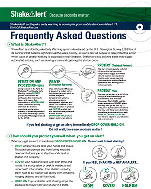
ShakeAlert FAQThe Clackamas County Office of Disaster Management is preparing for a major earthquake and we want you to be prepared, too. Please find a list of resources and steps you can take to better safeguard your home and family against disaster.

Preparing for an earthquake

There are lots of steps you can take to be as prepared as possible! Here are just some of the ways you can take care of yourself and loved ones ahead of time:

Step
1

Sign up for the Public Alerts notification system

In a disaster, Clackamas County sends out vital information through a telephone emergency notification system. The system is already programmed with our county's landline phone numbers but you must sign up manually to receive alerts via your cell phone or email. This also works with Voice Over Internet Protocol (VOIP).

More options to stay informed:

Step
2

Create Your Family’s Emergency Kits

  • Go Kits allow you, your family and pets to have what's needed in case you must evacuate.
  • Stay Kits provide you and your family with the means to stay in your home for an extended period of time, as supplies might not be able to be delivered to your area for weeks.
  • Camping Kits give you and your family direction if you need the option of camping in your backyard or elsewhere.

View a short checklist for each of these kits from PublicAlerts.org

Step
3

Know Your Area

There are many online tools hat can give you a quick analysis of how an earthquake will affect your immediate area. By plugging your address into the PDX Ready tool, you can see the predicted intensity in your area, the estimated recovery time for the community, and tips on how to prepare.

Step
4

Conduct an Earthquake Home Hazard Hunt

It is essential to safely secure heavy objects inside your house so that they don't fall on anyone.

  • Do you have a big-screen television? Is it strapped down?
  • What about large pictures or paintings that could fall on someone’s head?
  • Are your bookcases and shelving attached to the wall? What about your water heater?
Step
5

Know Your Gas/Water Shutoff Points

In a disaster, gas leaks and water breaks are possible. Know where you can shut these off in your house or apartment if you sense a rupture. Learn more at NW Natural.

What to do during an earthquake

Indoors

Indoors

Drop, Cover and Hold On. First, DROP to the ground. Then take COVER by getting under a desk or table — or if you aren't by either of those, cover yourself with your hands. HOLD ON to something sturdy.

Outdoors

Outdoors

When the ground begins to shake, move quickly and safely into the open, away from electrical lines, trees and buildings. Drop to the ground and wait for the shaking to stop.

In bed

In Bed

If you awaken during an earthquake, stay in bed until the shaking stops and protect your head with a pillow. You place yourself in a much better position to avoid injury by doing so.

Store

Stores

If possible, move immediately away from shelves and displays that may fall over or hold objects that could fall. Then drop, cover and hold on.

People in stadium seats

Theater/Stadium

If you're in a place with long rows, if possible get on the floor between the rows and cover your head with your arms. If not, stay in your seat and protect your head with your arms. Do not try to leave until the shaking stops.

Person in a wheelchair

Wheelchair

If you are in a wheelchair, stay in it. Move to cover if possible. Lock your wheels and protect your head with your arms.

Driving a car

Driving

Carefully bring your vehicle to a stop at the side of the road away from traffic. Do not stop on or under bridges or power lines, or near roadway signs that might fall. Once the shaking has stopped, you can continue driving, but watch for possible damage to the roadway.

What not to do during an earthquake

An earthquake is a disconcerting thing. Many individuals react without thinking and take the wrong actions. Here's a quick list of actions to avoid:

Don't run outside

Do not run outside

The exterior walls of a building are the most dangerous place to be, due to falling windows, facades or other structural debris. Stay inside if inside, or outside away from buildings if outside.

Don't move to other rooms

Do not go to other rooms

The shaking can be very violent, causing you to fall down and injure yourself if you try to walk or run. Drop immediately.

Don't stand in a doorway

Do not stand in a doorway

It is a common misconception that standing in a doorway is the safest place to be in a house. In modern houses, doorways are no stronger than other parts of the house. It's difficult to brace yourself under a doorway, so your best option is still under a table instead.

Don't get into the "Triangle of Life"

Do not get into the "Triangle of Life"

In recent years, a popular circulated email provided an alternative to the Drop, Cover & Hold On system. This email is based on several incorrect assumptions and we strongly advise you to ignore it.

New Format?
On

Volunteering During a Disaster

If you're interested in volunteering to help others during a disaster, we encourage you to seek out opportunities with the organizations that support our communities. For more information, please reach out to these organizations to see if there are opportunities that will fit your skills:

Depending on where you live, there may also be opportunities for training and/or involvement in a Community Emergency Response Team (CERT). We do not sponsor CERTs at the county level, but many agencies within the county offer CERT training. Each community will vary in the way they use their CERT in support of disaster preparedness, response and recovery. If you live within one of the following jurisdictions, please contact that agency directly for more information:

New Format?
On

PublicAlerts Notification System

ClackCo Alerts logo By providing contact information, county residents can opt-in to receive critical emergency messaging via email, phone call and text during times of disasters. Important messages that could be relayed include notices to evacuate, shelter-in-place, shelter locations and other extremely important information.

The system is programmed with landline phone numbers, both listed and unlisted, from telephone company records. You must sign up here in order to receive alerts by:

  • Cell phone
  • Voice Over Internet Protocol (VOIP)
  • Email
  • TTY/TDD Devices

If the call is picked up by an answering machine, it will leave a message and not call back. If the number is busy or there is no answer, the system will try contacting your other contact methods. Once you have acknowledged receipt of a message on one device, the system will stop trying to contact your other devices.

By signing up, you can receive emergency notifications for your home or any other address (such as a business). You will only be contacted when the associated address is affected by an emergency.

Current Alerts

Tips

  • Mobile phone users: You may receive a popup asking you if you want to use the Everbridge mobile app. If you do not want to use the app you may click cancel and you will be directed to the registration page.
  • Remember to use the “sign up for notifications” button to create an account in the new system. Once you have created an account you will then be able to login to edit your information.

The Technology

17081

FAQ

17166
New Format?
On

Sandbag Locations

Alert! During flooding events, call ahead to ensure sandbag availability. Sandbags are for residential use only. All sites are self-service. Bring your shovel!

Sites have a limited quantity of bags on hand. Please purchase more if you will need a substantial quantity.

If your city is not listed, please contact your public works department to see if they have a pick up site.

County-sponsored sites

These sites are for all county residents. Check with the other sites to determine jurisdiction and availability.

BoringEagle Creek Fire Station
503-663-4638
32200 SE Judd Road map
CanbyCanby Public Works
1470 NE Territorial Road map
MilwaukieClackamas Fire District #1 Station 4
503-742-2600
6600 SE Lake Road map
West LinnWillamette Park
503-656-6081, press 0
1100 12th St. map

City sites

These sites are for residents of the city.

BoringBoring Fire Station
503-663-4638
28655 SE Hwy 212 map (behind station)
EstacadaEstacada Public Works
777 NW Tulip Road map
GladstoneGladstone Public Works Department
Monday to Friday until 3:30 p.m.
Call 503-656-7957 before pick-up.
18595 Portland Ave. map
(This site is for Gladstone residents only.)
Lake OswegoHazelia Field
503-635-0280
17800 Stafford Road map
MilwaukieCity of Milwaukie Public Works
6101 SE Johnson Creek Blvd,
Milwaukie, OR 97206 map
Check in at office from 8 a.m. -5 p.m. Site is open 24/7
MolallaBohlander Field
503-829-6855
After Hours: 503-829-6855
On Shirley St. across from Buckeroo Rodeo Grounds. Next to Clark Park. vicinity map
Oak GroveOak Lodge Water 
503-654-7765
For customers only – call for availability.
14496 SE River Rd map
WelchesHoodland Fire District Main Fire Station
503-622-3256
69634 US-26 map
West LinnBehind the old Bolton Fire Station
503-656-6081, press 0
6000 Failing St., just off Hwy 43, access is from Failing St. map
New Format?
On

Upper Sandy River Flood Resources

A combination of weather, geology, hydrology and development (e.g., buildings and roads) create chronic seasonal flooding conditions along the Upper Sandy River.

In their natural state, rivers and streams move over time. This process is called channel migration. While the Sandy River was engineered in the 1960s to minimize channel migration, flood events continue to result in erosion and the river channel's periodic relocation.

Historic flood maps of the Upper Sandy River have not taken channel migration erosion into account. We recently added the Channel Migration and Historic Migration Zones to the existing FEMA flood maps.

Community survey

This 2016 survey asked residents about living with the Upper Sandy River, including about flood insurance, flood mitigation and preparedness priorities, and support for government efforts to reduce flood risks.

Map your flood risk

Our map tool helps property owners along the Upper Sandy River evaluate the risk of flooding and channel migration to their property. If you own property in one of the following communities, you can assess your flood risk using the map tool:

  • Marmot
  • Brightwood
  • Wemme
  • Welches
  • Rhododendron
  • Zigzag

View the map

Channel Migration Zone (CMZ)
Located between the red lines, this is the broadest flood risk zone for the area along the Upper Sandy River. These boundaries show the possible amount of channel movement in a 1964-scale flood event when up to 600 feet of lateral erosion occurred.

Historic Migration Zone + 100-Foot Buffer
Located between the purple lines, this is an area where the Upper Sandy River has occupied when channels shifted during the 100-year period between 1914 and 2014. A 100-foot buffer was added to show the possible amount of channel movement in a repeat of a 2011-scale flood event when about 100 feet of lateral erosion occurred.

FEMA 100-Year Flood Zone
Indicated by the hatch marks on the map, this is the area defined by the Federal Emergency Management Agency (FEMA) on Flood Insurance Rate Maps. This area is defined as a special flood hazard area with a 1% chance of flooding in any given year and requiring flood insurance coverage. FEMA periodically updates the 100-year Flood Zone; the Flood Zone on the current maps is the last adopted version.

Studies

We've commissioned studies to assess flood risks on the Upper Sandy River.

Bank stabilization

Riprap is a layering of rocks intended to reduce erosion along a stretch of riverbank. Although widely used in the past, riprap can have negative impacts on the surrounding environment, as it tends to increase the speed of water flow along the armored stretch of river.

Engineering With Nature: Alternative Techniques to Riprap Bank Stabilization provides alternatives to riprap stabilization.

Community handbook

Restorative Flood Response Community Handbook, a project of the Sandy River Basin Watershed Council, this handbook is the product of several years of community dialog, research, and collaboration among residents, experts and agencies.

Flood of Information event

Flood of Information: Preparing for Winter on the Sandy River is a free event held each fall. This event is open to all Clackamas County residents, property owners and businesses interested in learning how to prepare for winter weather conditions and emergencies on Mt. Hood and surrounding flood-prone areas.

No Adverse Impacts (NAI)

No Adverse Impacts (NAI) seeks to expand our collective focus to include how changes to the built environment can impact other properties. NAI broadens property rights by protecting the property rights of those that would be adversely affected by the actions of others. NAI is a project of the Association of State Floodplain Managers.

Oregon Channel Migration Zone (CMZ) policy group

Final Report

Oregon Solutions Letter
A letter from Board of County Commissioners to request the support of Oregon Solutions to convene an Oregon Channel Migration Zone (CMZ) policy group to address the absence of state policies related to CMZs and their impact to public safety and healthy habitats.

New Format?
On

Landslides

The size of a landslide usually depends on the geology and the initial cause of the landslide.

Landslides can be broken down into two categories: rapidly moving or debris flows and slow-moving. Rapidly moving debris flows present the greatest risk to human life, and Debris Flow Warnings are issued when soil has been so saturated that it becomes unstable.

Weathering, the decomposition of geologic materials and human activity produces conditions conducive to landslides hazards in Clackamas County.

Homeowner policies normally do not provide coverage for landslide hazards. The National Flood Insurance Program (NFIP) provides coverage for flooding, but landslide coverage is minimal.

Landslide Hazards in Oregon fact sheet

Homeowner's guide to landslides

New Format?
On

Disaster Preparedness

Prepare! A Resource Guide
A 20-page booklet about ALL aspects of preparedness including sections for specific disasters developed by the Cascade Region chapter of the American Red Cross in collaboration with regional Emergency Management professionals.

Family Plan

Visit Ready.gov for information on planning ahead for disasters. En Español

Public Alerts also has a page dedicated to checklists related to disasters

Business Preparedness

Faith Community Preparedness

School Preparedness

Neighborhoods

Neighborhoods that are prepared for emergencies and disaster situations save lives, reduce the severity of injuries and trauma and reduce property damage.  In addition, working together as a team and contributing as an individual develops stronger communities and improves the quality of life in the community.

New Format?
On