Translate


Let us know your preferences for the future of the Park Avenue area by taking our survey.
Take the Survey Responda la encuesta en español
Watch the Webinar
Check out these videos from the webinar:
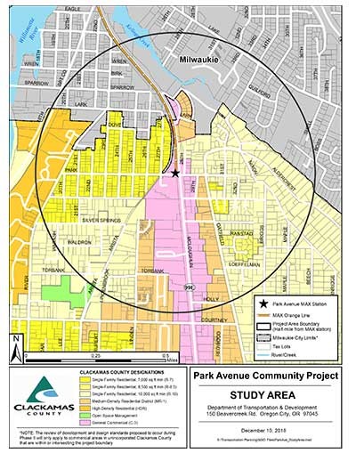
Click to Enlarge
WHAT: How can we make a more walkable, mass-transit friendly community? Clackamas County is working with Oak Grove neighbors to create updated land-use development and design standards for the area near the Park Avenue Max Station. The goal will be to support economic growth and protect neighborhoods around this area.
WHERE: Within a half mile of the light rail station at Park Avenue and McLoughlin Boulevard in Oak Grove, just south of the city of Milwaukie.
GOALS:
- Increase employment opportunities, promote innovative business ventures and enhance access to business and community services, amenities, while remaining sensitive to existing businesses.
- Increase the diversity and accessibility of housing choices adjacent to transit, along McLoughlin Boulevard, and along the near side streets, while maintaining sensitivity to existing residences.
- Provide safe locations, crossings and connections for walking, biking, transit and parking.
- Cultivate a heart and hub of neighborhood activity supported by a network of community gathering spaces that are safe and welcoming both day and night.
- Treat natural systems as a benefit and an integral part of our community identity by preserving, promoting and enhancing native natural elements at a variety of scales.
- Promote resilient, sustainable systems and infrastructure.
What we heard so far: We learned from people who attended our last workshop in February that they interested in the following community features to be a key part of future design of the area.
Jobs opportunities
- Local grocery and small businesses to serve the neighborhood
- Diverse choices jobs and businesses
- Retail
- Childcare
Housing
- More housing density, but designed appropriately for the area
- A range of housing types in varying densities (such as duplexes, apartments and co-housing communities
- Housing for workers
- Housing development that prioritizes accessibility for pedestrians and bicyclists, with flexible parking solutions, green spaces and required sustainability features
Transportation
- Improve access to Park Avenue station area
- Promote equitable access to all modes
- Improve safety along the Trolley Trail
Community Gathering Spaces
- Space for food trucks, dog parks, places to play and have events
- Encourage open space around housing development
Green Spaces and Natural Features
- Preserve existing trees and natural features
- Planted median on Highway 99E (McLoughlin Boulevard)
- Encourage courtyards and green roofs
Sustainability and Climate Resiliency
- Eco-sensitive housing density
- Community gardens to support surrounding housing
- E.V. charging and/or car share
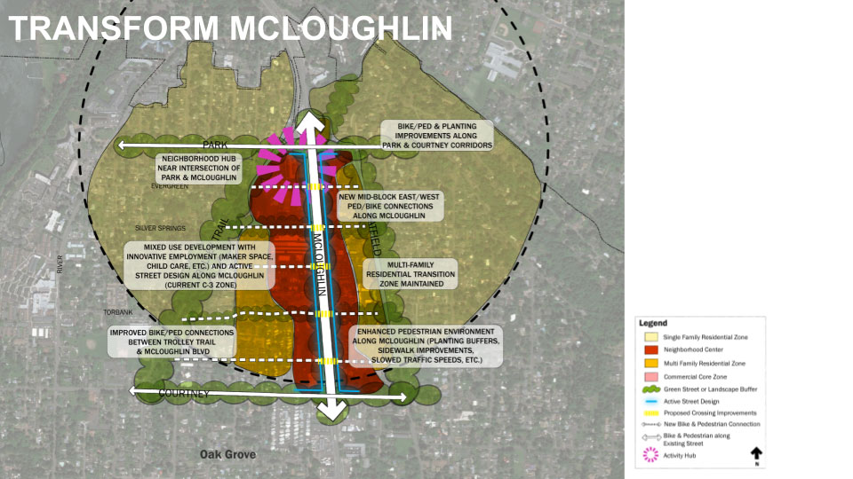
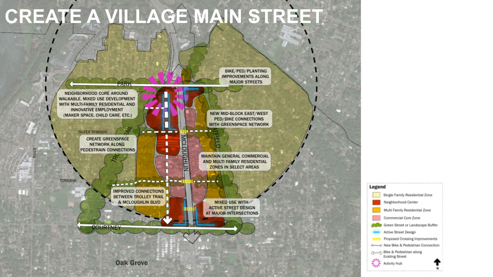
Two alternatives to consider
A framework plan is a map that shows a 20-year vision and big ideas for the future of a neighborhood. The framework plan helps inform design and development standards, but it is not a zoning code and it is flexible enough to adapt to changing conditions in the community.
What is in a framework plan?
The framework plan provides suggestions for locating the following elements:
- Types of development (housing, job opportunities, businesses, etc.)Pedestrian and bicycle improvements (like paths, sidewalks, etc.)
- Street crossing improvements
- Hubs of neighborhood activity and community gathering spaces
- Opportunities for landscape and planting improvements
|
Option A |
Option B |
|
|
|
|
The Transform McLoughlin alternative is focused on improving conditions along McLoughlin Boulevard to make it more conducive to development and inviting to pedestrians. It maintains McLoughlin as the primary circulator for auto-oriented and bike/pedestrian traffic, but offers substantial improvements along McLoughlin to make it safer and more accessible for everyone.
|
The Village Main Street alternative concentrates mixed-use development (retail and housing), and bike and pedestrian traffic along a new corridor parallel to McLoughlin, between McLoughlin and the Trolley Trail and adjacent residential development.
|
Now, we’d like give you a chance to let us know your preferences for the future of the Park Avenue area. Just click on the Survey link below. Thank you!