Year Formed: 1989
Area: Approximately 8,960 acres on the west slopes of Mt. Hood.
Purpose: To target public investments toward revitalizing this mountain community and encourage private developments such as resorts, hotel and condominium units, retail projects, restaurants, recreational facilities and single family homes
Assessed Value: $160 million in 2010, up from $24 million in 1989; collected tax increment financing revenues through June 30, 2008
Overview: Nestled on the slopes of Oregon's highest mountain peak, Government Camp Village is surrounded by Mt. Hood National Forest, which provides a wide range of year-round recreational opportunities and scenic vistas to residents and visitors. Located an hour from downtown Portland and within a few miles of three heavily-used alpine ski resorts, the community has the potential to be the destination recreational and retail center of Mount Hood.
Economic growth was slow in coming to this community. Over the past four decades a series of small fires, the relocation of Highway 26 around the village core, poor visibility from the highway, minimal infrastructure improvements and inadequate maintenance of public and private facilities have contributed to the slow economic improvement.

Current Projects
- Skibowl Waterline Extension
A new 12-inch waterline will be extended approximately 1,200 feet to the Skibowl base area to provide the fire protection necessary for future development. - Fire Station Remodel
The Development Agency is partnering with the Hoodland Fire District to remodel the existing fire station to accommodate more service vehicles and larger crews.
Completed Projects
Development
- Building Facade Improvements
The Agency has helped business owners improve their building facades to better reflect or achieve the Cascadian architecture style. Nineteen properties have been improved. - Development Assistance
The Agency contributed to the cost of installing utilities, fire sprinklers and architectural upgrades to building faces for the 26-acre Collins Lake condominium development. The Agency also contributed to the cost of public parking, sprinkler installation, other public amenities and architectural upgrades for a new mixed-use building on the Government Camp Loop Road - the first new commercial development in the community in many years, with 5,400 of retail space. - Development Incentives Plan
This plan helped to refine and prioritize projects in the revitalization plan, and evaluate private development opportunities and constraints.
Community
- Blight Removal
Debris and old equipment were removed from public and private properties during a community-wide clean-up in fall 1990. - Employee Housing
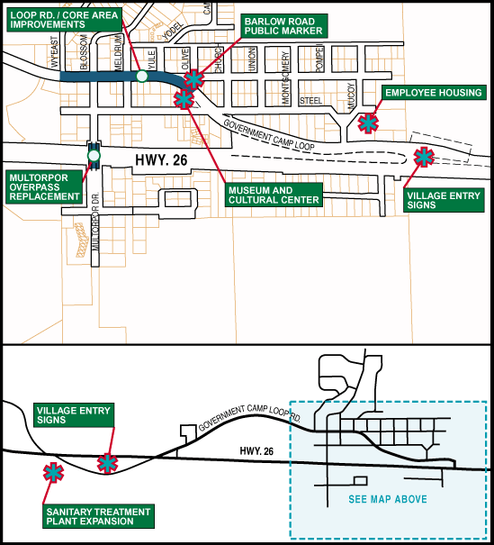
The Agency contributed $240,000 toward construction of a 48-unit complex of affordable housing for area employees. - Maintenance Mechanism
The community approved formation of a special road district in 2012. The district is responsible for maintaining the roads, drainage, sidewalk snow removal and lighting. - Museum and Cultural Center
The Agency contributed to a feasibility study for construction of a multi-use facility for community gatherings, classes, events/receptions and exhibits that focus on the history of Government Camp and the Mt. Hood area. The Government Camp Historical Society, with Agency support, purchased and renovated a building for this purpose. - Improvement of Residential Streets
The project funded streets throughout the community. Existing overhead utilities (electrical, phone, and cable) were placed underground in the core area and on Lige and Meldrum streets to improve the aesthetics of the community and minimize future maintenance of utility lines.
Design
- Design Guidelines
Core area design guidelines were developed and adopted to provide for implementation of the Cascadian Design theme for new development and redevelopment. - Building Fa?ade Improvements
The Agency has assisted business owners interested in improving their building facades to better reflect or achieve the Cascadian architecture style. Nineteen properties have been improved. - Improvement of the Barlow Road Marker Public Space
The Barlow Road monument at the east end of the village center serves as both a tourist attraction and community focal point. Improvements include seating, landscaping, flagpoles and a display kiosk. - Installation of Village Entry and Business Directory Signs
New entrance signs at each end of Government Camp Loop identify Government Camp and invite visitors off Highway 26. The Cascadian-style signs are lighted and surrounded by landscaping. Businesses were also reimbursed for replacing existing business signs with Cascadian themed signs.
Infrastructure
- Sewer Line Extensions
The Agency partnered with the Government Camp Sanitary District to construct two line extensions to facilitate new development south of Highway 26 and in the eastern part of the community. A portion of the line was completed in 2008. The remaining 1,800 feet of line was installed in summer 2010. - Water Main Construction and Fire Safety Improvements
Approximately 10,200 lineal feet of 8"-12" water line and 20 hydrants were installed to provide fire flows to most of the community, including the new Still Creek development. In 2007 a 12-inch water line was placed across Highway 26 at the west intersection to provide adequate water flows for a new subdivision and any other future development in that part of the community. - Sanitary District Treatment Plant
The plant, which was completed in 2000, provides capacity for new development in the community. - Geothermal Energy Study
The Agency completed a study of the availability of geothermal energy sources and the feasibility of their use. - Snow Management
The Agency supported the development of a community-wide plan for storing snow. The plan includes policies and procedures to be followed by snow removal contractors. - Utility Undergrounding
The Agency worked with the various utility companies to place their service underground in several locations throughout the community.
Transportation
- Multorpor Drive Street Improvements
Approximately 400 feet of street improvements, including drainage, sidewalks, lighting and landscaping, was constructed in 2012. - Steel Lane Pathway
A new pedestrian pathway was constructed within the Steel Lane right-of-way, to connect Multorpor Drive to the Mt. Hood Cultural Museum. The project was completed in fall 2010. - Urban Transportation System Plan (TSP)
The Agency developed an urban transportation system plan to determine what, if any, road improvements would be necessary to facilitate community development. - Loop Road and Core Area Improvements
Paving the Government Camp Loop Road, completed in 2003, was funded through a $584,000 grant from the Oregon Transportation Investment Act (OTIA). Core area streetscape improvements, completed in 2004, included lighting, landscaping and street furniture, storm drainage and catch basins, and walkways. - Parking Management Plan
The Agency developed a plan to facilitate the management of parking in the community. A parking expansion plan provides strategies for the community as the demand for parking space increases. - Multorpor Overpass Replacement
The old overpass was replaced to improve access and safety. Multorpor Drive was also improved, with new sidewalks, lighting and landscaping. Construction began in March 2007 and was completed in fall 2009. - Trails Master Plan and Improvements
The plan identifies improvements needed to the existing trail network to enhance visitors' experiences of the National Forest. Portions of improvements recommended in the Government Camp Trails Master Plan were constructed, including improvements to existing trailheads, signage and new trails. Construction on approximately nine miles of new, multi-use trails was completed in 2007, a trail from Timberline Lodge to Government Camp, and a new parking area and trailhead for Nordic skiers. - Aerial Tram System
A preliminary Feasibility and Fatal Flaw Analysis for an overhead transportation system on Mt. Hood was completed.
 Translate


